I have always loved maps, especially Ordnance Survey maps. I have loads of them and love to read them like books, and they really come into their own when planning for a journey, trip or holiday is required. I really toyed with the idea of buying the ones I don't have for all of our journeys but the cost would be a fair bit and storing them would also be a problem. On the canals, when we were hiring I used the Pearson's Guides. I'm not sure why I started with them but did enjoy the irreverent comments and the historical aspect of them. The maps are hand drawn and well annotated. The orientation is done to try to get the canal leading across the page so North is definitely not always up! I also like the comments about what the towns and villages along the way are like. Some are tongue in check and others allow you to read into them, but nowhere is condemned, and there always something positive said about the stopovers. The Pearson's obviously are not only wedded to the canals but railways too. All the old lines and stations are shown, along with transshipment basins etc. I do like the historical element of these guides.
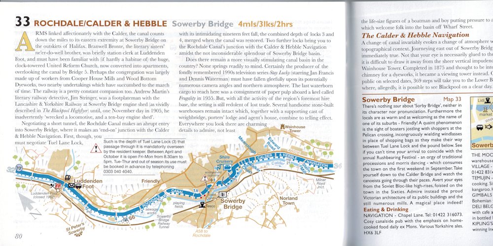

The latest style of map in the Pearson's Guide. I am still getting used to this layout. I personally don't think they are as clear as the old style.
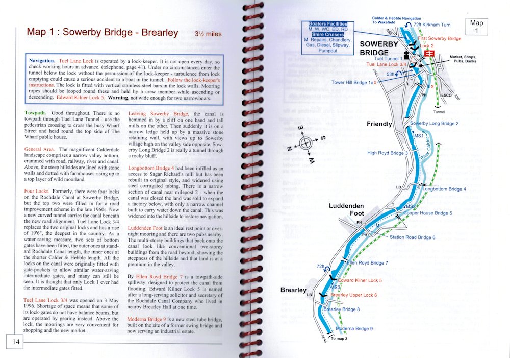
The other main guides in use are the Nicholson's guides. These were first published in 1970's by Nicholson's but are now published by Bartholomew and the Ordnance Survey. They are based on the OS maps and I love my OS maps. There is a little bit of the map off, away from the canal so this gives you scope for sorting walks etc. As they are OS maps they always have north at the top of the page. I am used to this and it means I can always tell which way is which. I quite often find using the Pearson's Guides that I have to hold the map with north up so that I can sort myself out. The narrative on Nicholson's is usually more straight forward and less informative. Quite often the information for the map is not on the same page. This is likely to be due to having to have north up means that not enough space is left on the page. The guide is spiral bound which means that the spine isn't broken when using it.
Nicholson's Guide pages.
This year we will be cruising areas where there is either no guide for it or I feel that a 'second opinion' was required. I had heard about Richlow Guides and so had a look into them. They are written by Christine Richardson and John Lower, hence Richlow! They are both boaters and so have designed the guides the way they want to use them. They are both heavily involved with the restoration of the Chesterfield Canal and as this is is only accessed from the Trent they have sailed the waters off that river too so first hand knowledge. My new Richlow guides have arrived today and so I have had a nice couple of hours reading through them. I had trouble ordering items from their website but an email to John Lower was very quickly answered. It seems there was a problem with PayPal rather than their website. The guides are slim spiral bound with plastic covers. The maps are uncluttered but have good information on them. The information regarding the places passed is good and relevant to the boater. The navigational information is very useful. There are historical sections along with lists of pubs and town maps. They look easy to use and easily read and I can't wait to use them when we get away. On the Richlow website they have updates that you can check out. Their 'motto' is 'written by people who go there' so they welcome anybody getting in touch with any changes or items missed to keep them as up to date as possible. The maps are like the Pearson's with the canal placed on the page to get the most on so north moves around. One thing I have noticed is that they don't have the number of locks summed up on the page so you have to count them from the page, like Nicholson's. All the maps have the mileage covered on the page but only Pearson's have a estimate of the time taken to cross the page. Nicholson's have each mile marked of on the map.
Richlow Guide pages.
So far the Richlow Guides cover the waterways off the Trent and Ouse, the canals to Sheffield and the South Pennine Ring. These are waterways that are under boated compared with the Shropshire Union or Grand Union and that is one of the attractions for us. I think with all three guides for some of the waters we will be travelling we will have the best of all worlds. I'd like to thank John Richlow very much for his very prompt assistance in getting the order sorted for me. Under three weeks now before we set off. I hope this weather lasts till then!
2 comments:
I hardly ever get my canal map books out now. I use Paul Balmer's maps, they are so very up to date and I can just follow my way on my phone propped up in front of me as I steer and know exactly where I am with the little gps circle following the route.
I'll put the link in but please remove if you feel it is unfit to post.. http://www.waterwayroutes.co.uk/wr/maps.html
Hi Sue, I only have a clock work phone, and that is just recently upgraded as I now have Helen's phone because she has upgraded to steam power! I did think about a GPS thing for the walks and maybe geo-caching but I can't bring myself to do it. I like to see the whole picture and not just the little screen with your little bit on, or so large that you can't make anything out. Maybe one day I will join the new cartographers, but I do love my OS maps, Admiralty charts and the like. A GPS will never replace a A.A Wainwright Lake District guide for instance. I hope Meg's leg is okay soon and that you find the weather getting even better as you head north. Cheers for now, Tony
Post a Comment