Total Pageviews

Saturday 9 December 2017

July by bridge and lock, part 2.

You left us heading up the River Derwent. It is a shame that there is no passage to Satmford Bridge anymore as that would have been a nice trip to make and a bit of an adventure. It would be nice to think that the various responsible bodies could get their acts together and restore Sutton Lock and open up the route once more. It would be a relatively cheap way of restoring another 10 miles to the waterways.

When you arrive at Cottingwith Junction, where the arm off the river heads towards the Pocklington Canal you have to keep your eyes open as it is not at all obvious. The trees were much overgrown and it could easily have been missed. When we came back out this way we saw a sign that was mostly hidden. After a little way you come to Cottingwith Lock. They are fitted with the wheel type paddle gear but otherwise all seemed normal. As we arrived there was another boat going up ahead of us.

We had been warned by others that there could well be a weed problem and after a very short distance we realised that we had underestimated the problems as we had never really encountered weed to this extent. The first couple of miles was the worst and I think it was really because there were no trees shading the canal so the heat and sun light had really boosted the growth. It was just a matter of perseverance, going in reverse to try to rid the prop of weed until it didn't work anymore and then getting down the weed hatch to do a 'proper' job. After Haggs Bridge it got a bit better and quicker progress was made. This picture of the bridge was taken on the way out again.

Also in the two miles were a couple of swing bridges, aptly called No.1 and No.2! I think this is No.1 but they are the same design. This gave some relief from the weed pushing and also another opportunity to go down the hatch and clear the prop one more time. Unfortunately the weed cutting boat is out of action as it needs some expensive alterations.

By the time we reached Gardham Lock things were moving along more quickly but not clear of weed by any means. The lock has a swing bridge across the middle of it like Fenny on the Grand Union. Just another little quirk on this canal.

 After several hours of pushing weed to complete the 5 miles we arrived at swing bridge No.7. Just the other side of this is the entrance to the Melbourne Arm and our moorings for a while, kindly lent to us by a member of the Pocklington Canal Amenity Society. It is a pretty idyllic spot, nice and quiet with fish aplenty, walkers and boat trips to occupy you for some of the day but very peaceful for the rest of the time. In the above photo you can see there is plenty of weed and rush on the canal. This section is not open to navigation at present.

The next lock up on the non navigable stretch of 4 miles is Thornton Lock and it has just been refurbished. This weekend they were having an open day to the public. We had a sneek preview and an interesting chat to the C&RT guys there. You can see above the lock the waterway is chocked with weed. It actually wouldn't take too much get this open again and through to the Canal Head about a mile short of Pocklington.

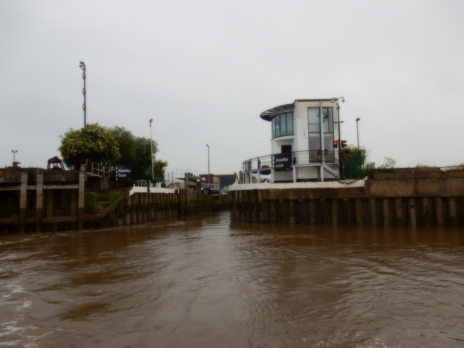
After a few days back at home we followed our route back to the barrage at Barmby. We stopped for a night on the pontoon at Barmby and had a great meal at the King's Head in the village. We also had a great meal at the pub in Melbourne so we will be back to both in the future I'm sure. I had been to see the lock keepers and they had given me a time to be at the lock for our pen out on to the Ouse fro the next part of our trip. They keep the whole area in tip top condition. In this photo you can see the floating fence that prevents going over the barrage and the piles that mark the lock entrance.

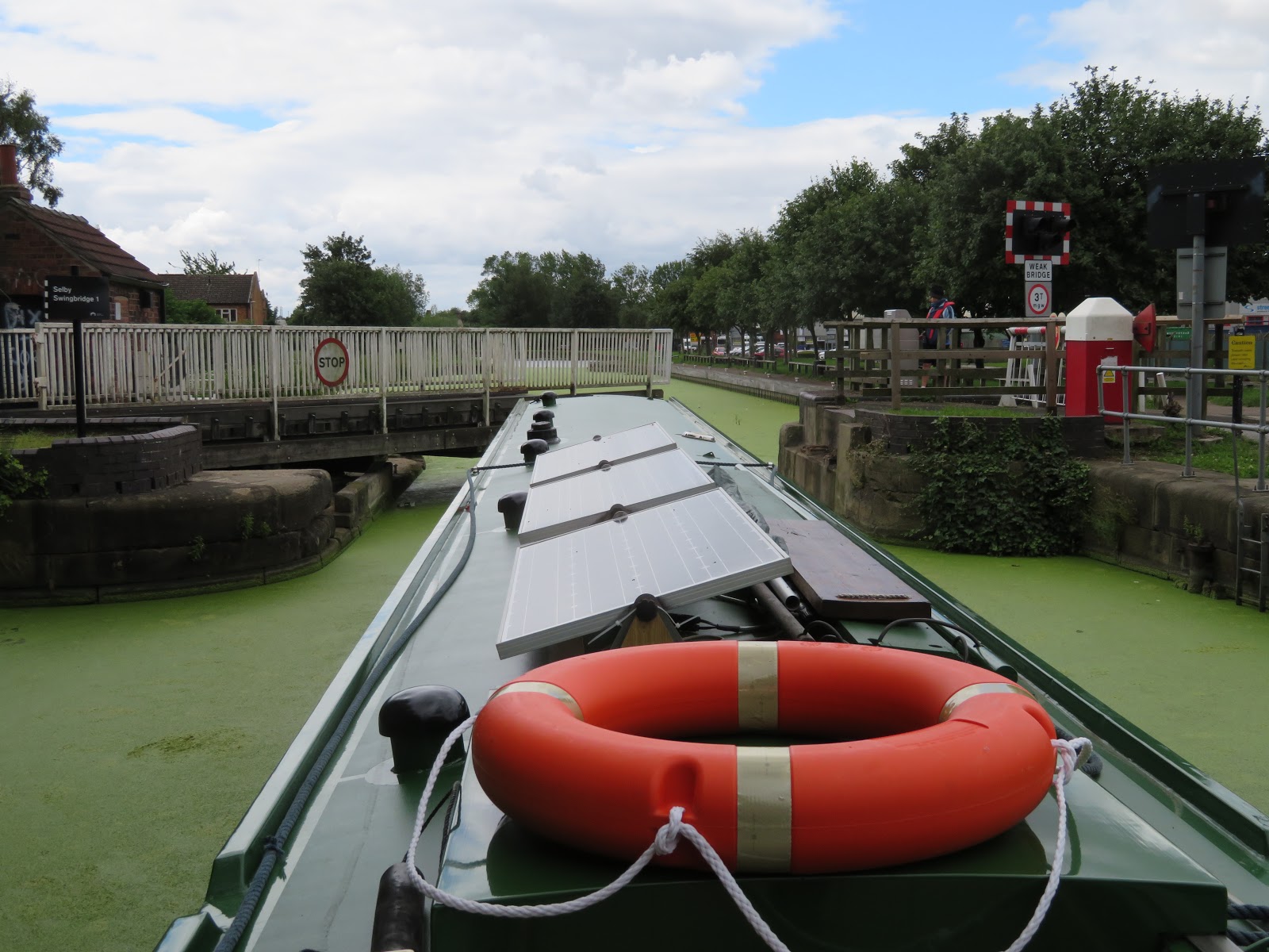
The tide was flooding up when we popped out of the lock. We were heading for Selby which was only about 6 miles away. It would obviously be beneficial to arrive when much of the flood tide had abated so we were in no rush at all to get there. In fact we spent most of the trip in neutral just putting 'Holderness' in gear to straighten up and get round the bends! Saving fuel I suppose but got a little funny when the tide started setting us down on to the banks of the bends. We were soon approaching the Selby bypass swing bridge. I was interested to see that a set of pontoons had been placed either side of the bridge to allow vessels waiting for the bridge to hang a rope up to rather than have to dodge about in the river.

Once more having never been this way before it was quite difficult to spot the entrance to the lock for the Selby Canal from any distance, but was obvious when you arrived. We were soon round and shaping up to make our entrance. As usual it seems there were several folk standing waiting so you mess up, of maybe watching and learning to see how you do it. There is slack water just inside the knuckle of the lock so once you have angled in at a nice slow speed over the ground a little kick to get the bow round into the lock is all that was needed. I managed not to disgrace myself once again.

There was just us coming up and we were soon towering above the river level. In the summer months the Selby Canal is full of weed and the first clue you will have of the lock from the river is the banks of weed that are flushed out every time the lock is used. As you can see the weed is so think it does look like a lawn and the coots and moorhens are in there element as their big feet mean that they can walk on it and not have to swim.

There was no room at the basin area near the lock, but we had booked a berth at the Selby Boat Centre as we were heading home again. The weed continued all the way to our allocated slot and we had to literally dig our way in to the mooring as we came alongside to get right flush to the wall. Before that there is one more obstacle of an electric swing bridge. This road must be a short cut to an estate or something because every time we used it we held up loads of traffic! That's Helen working the controls despite being dressed as a C&RT volunteer!

See where we get to in August in the next exciting episode of Bridges and Locks.


Monday 4 December 2017

July by bridge and lock, part 1.

The trip down from Beverley to Hull was the reverse of the way up, in as much as it was just the reverse of the bridges on the way up. Instead of worrying about not being able to fit under the last bridge, the navigational problem was to ensure that we cleared the River Hull as early as possible to give us plenty of time to get right up the Ouse, but to ensure that we had enough water to float when in the River Hull. We left Beverley about 2 hours before LW Hull and despite some 'slight' adventures we got to Sammy's Point by The Deep 3 hrs later, so an hour after LW. I reckon we could have easily left 30 mins later and we would have meet the incoming tide a little further up the Hull.

Once we got on the Humber there was a bit of a wind from the west that had a bit of a chill. Pretty soon it came round to the east, as forecast and it became a pleasant day. We decided to take the northern channel that is not buoyed but on a rising tide would mean we there would be no problem and we would have a different view of the Humber. Passing under the Humber bridge is always a thrill as it may no longer be the longest in the World, but it is pretty beautiful.

Not really knowing how long everything would take we maintained a good speed and made the junction of the rivers Trent and Ouse at the Apex Light in two and a half hours so at an average speed of 6.7kts. We were now on the Ouse and heading to Goole. It was very calm and peaceful and pleasant. We passed Goole an hour later so making a speed of about 10 kts. As we passed the port we had a good view of the old Ouse lock, to the left that you can see is disused due to the bank of mud in the mouth of it, and Victoria Lock that is in use and whilst not quite as wide as Ocean Lock, it is nice and long. We were able to slow down even more as the closer to HW at Barmby Barrage the better as there would be less flow on the river.

The next obstacle was Skelton Railway Bridge. We had been informed of an outward bound vessel from Howdendyke, and on the radio we could hear that we were going to meet around the bridge. The bridge was built in 1869 and over the years has had a few strikes from shipping. There is a slight bend at the site of the bridge and the current doesn't flow directly through the bridge, so setting you onto the structure. It was nice to see a commercial ship on the river.

After passing Hook Ness, making sure you take the right side of the island as one side dries out, but no problem for us on a rising tide. Round the bend and the M62 motorway bridge comes into view. This is the next bridge across the Humber/Ouse after the Humber Bridge, and there is no toll. The bridge was opened in 1976.

Juyst through the motorway bridge you come to Boothferry Bridge which was the lowest bridge to cross to the north bank until 1981 when the Humber Bridge was opened. There was usually a big tail back due to the bottle neck. The Bridge Master came out to give us a wave

We arrived off Barmby Barrage 90 mins after passing Goole at 1645, about 45 mins before HW at Barmby. There was still a good run on the river, but it is nice and wide and swinging round, head to current is not much of a problem. The barrage is to the right of the picture and it was designed to maintain the level of water in the River Derwent and prevent flooding of the valley. The control cabin controls the lock and the barrage. The water levels in the river are watched and altered all automatically.

We had spoken to the Lock Keeper on the way up to keep us informed of our progress and he had said that he would have the lock open for us, but if he wasn't there, just to give him a ring once we were in the lock as he only lives close by. We swung round and started dodging in towards the lock which is separated from the barrage by the piles. This photo is actually from when we left as my camera battery had gone flat on the way in. There doesn't seem to be much room but you can get close to the knuckle, you can  just see some stone below the sign at the waters edge, and there the is slack water so you can 'bend' her in when close to it. The lock keepers are very friendly and helpful and the pontoon a little further up the river is just a nice walk to the village.


After a day on the pontoon and a walk into the village for a safe arrival pint we set of the next day to explore more new ground. The first bridge on the Derwent is the Loftsome road bridge. The small photo above was the toll bridge that was in place from 1804 until 1930's when the present road bridge was opened. It is quite a pleasant stretch of the river.

Not much further up the river is the railway bridge at Wressle. the Hull and Selby Railway was opened in 1840 and soon after Wressle Station was opened. Just through the bridge is the remains of Wressle Castle which was home of the Percy family from 1390's. The house was badly damaged in the Civil wear and then largely burned down in 1796 and what is left is just one wing.

This bridge has been in place since 1793 and was a toll bridge until 1936. It replaced a ferry that was dangerous at times. It has not been enlarged and has traffic lights to regulate traffic. Apart from the three main arches the road way is held above the flood plain by lower flood arches to either side. There are few places to stop and moor on the Derwent so we continued onwards, so more of that on the next blog.

Thursday 30 November 2017

June by Bridge and Lock; part 2.

The last blog found us heading up the River Hull and half way through the thirteen bridges that span the river within the city. I was nervous about the timing of the trip as we had to be able to pass under the last bridge otherwise we would be stuck.

The next bridge we came to was also the oldest. Sculcoates Bridge was opened in 1874. The 56ft span is crossed by the cast iron girder bridge which is counterbalanced over the land side. There is the short fixed span too.

The next bridge is the only rail bridge that now crosses the River Hull. It was built to replace an earlier bridge in 1907 by the North Eastern Railway. The railway closed in 1968 but it is still in uses as a footpath and cycle way.  You can also see the British Extracting Co Limited Mill in Wilmington that was designed by well known Hull firm of architects, Gelder and Kitchen and erected in 1919. It has some nice Baroque revival details in the 6+ stories. It was built to receive grains from river and road in collecting store and then placed in the silos ready for use. The soya, flax, cotton and rape seeds came from home and abroad and the big extracting industry that started up in Hull led to other industries like paint and machinery.

This bow string Wilmington swing bridge was built for the North East Railway in 1907 and still carries freight trains that eventually connect up with the eastern docks after a circitous route round the north of Hull.


As you can see the river level is coing up and the air draft is reducing. There was plenty of room to slip under the pair of Stoneferry that were opened in 1991, replacing a swing bridge erected in 1907. Before that there was said to be a ford here. One bridge carries a carriageway each.

Apparently the machinery and control room are neo- Georgian and the Sutton Road Bridge is a Scherzer rolling or walking bridge was opened in 1939 and looks very sturdy indeed. As you can see there is still plenty of room under this bridge.

 The Ennerdal Ling bridges were built in 1997 by the same builder as the Stoneferry bridges, and hence they look similar. They were needed when a planned partly built tunnel flooded. The air draft on a rising tide is crucial here as these are the lowest we have to pass under before high water. As you can see there is less room here, and I reckon I had another 30 mins before it was getting a bit dodgy.

Once through the Ennerdale Bridges we could relax and slow down a little to try and arrive at the Beverley nearer to high water. There had to be plenty of water to get over the sill, but with just 2 ft draft I don't think we need worry about that. We made it in the sun and after a little poke about we worked out how to make everything work. We had been given the combinations of the locks on the paddle wheels and even remembered to take the pin out connecting the two inner gates.

After a few days down on the Beverley Beck, with electricity, and plenty of visitors, we decided to continue our exploration of the River Hull and see how far we could get towards the original terminus at Driffield. The first obstacle would have been the Grovehill Bridge that was opened in 1953. We would have had to leave the lock as soon as possible to fit under the bridge but luckily the barge 'Syntan' was going on a jolly up river and would need the bridge lifting so we could tag on behind. The bridge replaced a ferry bridge. The area was the site of Cook, Welton and Gemmel ship yard that built tugs and trawlers in abundance.

 Almost he last two bridges on our trip are at Tickton. The first is the foot bridge that was erected in 1976 replacing a rolling bridge built in 1913 and through the span is the Tickton by-pass road bridge that is a standard concrete bridge built in 1974.

The head of the tidal limit is at Struncheon Lock, where there is also a weir alongside. The lock was built between 1803 and 1811 to Yorkshire keel size. The lock gear requires special windlasses to work them and we had been kindly lent them by the Beverley Barge Preservation Society. The 'Syntan' winded above the lock so we were on our own from here.

 Above the lock the route become the Driffield Navigation, rather than the River Hull, and the next navigational problem is Bethell's Bridge. The original bridge was built at the same time as Struncheon Lock as the new cut and removed a series of meanders of the river, but access was still required. There is a fixed section and a swing portion. By the late 1960's lack of maintenance meant it had jammed shut, plus damage from overweight lorries. The local framers needed access and so they did the work themselves along with other members of the Driffield Navigation Amenities Association. It was restored in the late 1970's and has been maintained in working condition since, if somewhat rudimentary.

We got as far as North Frodingham Wharf as after there there is nowhere for a 58'9" boat to wind. The navigation to Driffield is all but complete. The onky stumbling block to getting our boat to the river head is the low bridge that had become fixed and presently there is a problem with the riparian owner of the area so things are on hold. At least I think that is the problem. Above is the Struncheon Hill Lock on the way back down to Beverley on the way down. It was a great trip up and Beverley is certainly work the visit.

Tuesday 28 November 2017

June by bridge and lock, part 1.

We started June having been home to Hull, the City of Culture, for a week of volunteering and attending shows. We were governed by tides and times as we were heading to tidal waters. The Stainforth and Keadby Canal passes through the flat lands of Thorne Moor and despite there being few villages there are plenty of bridges to navigate.

The canal passes through the low lying land and so in any wind it can be quite exciting as you have to tack through the landscape. There are five swing bridges between Thorne and the Godnow Bridge above. They are all electrified so it is not too bad with a crew but must be awkward on your own.  The railway line runs very close to the canal on much of the route and two of the bridges are right next to the level crossings of the railway. At Godnow Bidge and level crossing I think that the keeper is in touch with the vazon railway bridge so they have advanced notice of your arrival.

There are several passenger trains and plenty of goods trains passing over these tracks and so you inevitable have a wait until there is a suitable gap in the traffic to operate the bridge. There was originally a swing bridge here but was replaced by this sliding bridge in 1925. It is pulled to the side by wires and was originally operated by battery. The original bridge was replaced once again in 2004 and is mains electrically operated and actualy opens the lines at an angle. The batteries are retained as a back up.

We had a couple of days to wait before it was our turn to head out of Keadby Lock. We had been to see the lock keeper and he had done his best to put us off our course of action but I just told him that if the worst came to the worst we would head back to him. As the River Trent is tidal there are two sets of outer gates one to keep the canal water in and one facing the other was to keep the high tides of the river out of the canal. To further complicate things there is a road bridge over the tail of the lock too. Our aim was to descend down the River Trent to it's junction with the River Ouse at Trent Falls, and where it becomes the Humber. We had to leave on a rising tide and push in to the current to have any chance of getting to Hull in time. The last words of the Lock keeper was that we were the first narrow boat he could remember that had turned left out of the lock, rather than right!

The weather turned out to be not quite as we had hoped it would be. There was supposed to sunny periods and little wind. It was overcast with drizzly showers and the wind was a little stronger than we had hoped too. The trip against the tide went as planned and we made the expected speeds. By Burton Stather the tide had changed and the speed picked up, but not quite as much as I had planned for! We had friends on the foreshore at Hessle, seen under the other end of the bridge in the photo above. I was worried about not having enough water to be allowed in the lock at Hull Marina so I was cutting all the corners I could to shave off a bit of time. As it was a falling tide I had to be a little careful

I called the Marina regularly with up dates as to our ETA and they said that there would be water enough for us at 3 hr 40 mins after HW. The published lock times for the marina must be for large vessels or with a keel. As we have only a 2 ft draft we were able to sneak in. Above you can see the lock is open and that there is plenty of mud showing in the outer basin. The first problem however was to get in the basin. We swung round head to tide a bit before the entrance so as we would drift down to the entrance rather than have to push against the current. You can see the push of the tide on the steel pier. It was then just a matter of angling the bow across the tide to edge further in and then out of the run of the current that can be up to six knots.

 We safely negotiated the entrance and were soon secure in the lock with ropes to the vertical risers along the lock wall. The lock is of the sector gate type where they provide the greatest range of tidal openings rather than having a permanent fixed sill and require enough water to support the gates. The sector gates rotate and 'crack' the seal to allow water in/out of the lock. The photo looks like there is a torrent but the keeper was very gentle with us. We were soon making a level with the marina and released to find our way to the allocated pontoon. Off the river the wind had dropped and the temperature risen adding to the joy of a safe arrival.

After a week or so in the marina it was time to move on. After some lovely weather the sun went to hide and it was a wet departure. The conundrum on departure was how soon we could escape the lock as we had to make a passage up the River Hull early enough so as there was sufficient water and not too much water so that we wouldn't fit under the many bridges. Just as we left the lock the heavens opened. Here we are clearing the lock, but still in the outer basin.

Next to the Marina entrance is the pier where the former paddle steamers that were the link between the Lincolnshire side of the Humber at New Holland and Hull. The entrance to the River Hull is at Sammy's Point where ships were once built but now The Deep 'submarium' sits. Straight away there are two bridges, three if you add the tidal barrier in. They are the footbridge between the Deep and the Fruit Market area (Millennium Bridge), the Tidal Barrier and the Garrison Road bridge. Bringing seagoing ships in to the Old Harbour was always 'interesting' as the tide pushes you in, there isn't much water between the banks, and a wrong move means that you are stuck, and the road bridge operators, that can be seen in the distance, do not want to open until the very last minute to save holding up the traffic. With the tide up your chuff there is little chance to stop and stay off the mud!

The next bridge is the newest, Scale Lane pedestrian Bridge which is the only bridge in the country that you can ride on when it opens and closes. As we passed the 'Arctic Corsair', the last Hull registered 'side winder' trawler, that is moored outside the Street Life Museum, the heavens opened for a short period, and then that was that for an increasingly sunny cruise up the \river Hull. The next bridge to come to is the Drypool Bridge that has been painted especially for the year of the City of Culture and to honour a man of Hull John Venn who was the man who 'invented' the Venn diagram. His father had been an evangelical vicar and worked with mission churches and grandfather who worked with William Wilberforce. It is a Scherzer rolling bridge. On the left are converted warehouses from the 1700's.

The next bridge is North Bridge. This was the first bridge that was outside the walls of the old town and clear of the citadel and garrison on the east (right) bank of the river. This bridge replaced another in 1928 and is another Scherzer 'walking' bridge. My Mum was born just a few yards to the right of the bridge. The site of the old bridge can be seen just before the present bridge.

The river was a busy thoroughfare for ships until about the 1970's, and the breadth would be full of barges bringing cargoes from the hinterland and transshipped from the big ships in the docks. There were many animal feed and seed crushing factories along the waterway as well as tanneries and other businesses. You can still see some of the old warehouses and mills from the water that aren't really apparent from the roads. The Scott Street double bascule bridge that was opened in 1901. It is now kept open, since 1994 as it is too weak to take traffic. It would be great to have it reopened for pedestrians at least.

We vare just about halfway through the built up area and still have six bridges to negotiate. As you can see the tide is still low but the mud is covered so we have no worries depth wise. The big worry for me was that the last bridge is actually the lowest and if we didn't get there early enough to pass under it we would be stuck until a falling tide and then may not get in the lock and off the river at Beverley Beck.

Thursday 23 November 2017

May 2017, by bridge and lock. Part 2.

From Sowerby Bridge we continued down the Calder and Hebble and to what we were led to believe was the shortest lock we would encounter on our trips round the system.

'Holderness' is 58'10" long and we had never been down the Salterhebble Locks in her. I think the middle lock is supposed to be the shortest lock and as we drained the top lock ready for our decent I did wonder about taking the front and bow fenders off, but didn't. As we lowered down with the boat in the lock it became evident that we did fit, just, but to make things easier I loosed the stern fender. The big problem came when we got down to below the cill. The bottom of the gate was leaking badly and as we had nowhere to go and the water was pouring in the aft deck. By the time I had managed to kick the bow round the one gate to open and then leave the engine hole was  quite full. I think that if I came this way again I would perhaps come down the lock stern first as there is plenty of room to turn before the second lock. The two locks were a staircase at one time.

The bottom lock of Salterhebble is another one with a guillotine bottom gate and luckily it is electified. Even more luckily the C&RT carpenter was busy replacing a foot board on the top gates so said he would close up afterwards so we were speedily through and non the worse for wear from our experience.

The River Calder accompanies the canal closely at this point, and indeed a canal bridge was washed away. At Brookfoot Lock the scene is quite picturesque with a lock, a keepers, or toll house and nice stone bridge. To the extreme left of the photo is another lock that used to pen down into the River Calder itself. The canal cut was dug between 1805 and 1808 so the lock must have been constructed then. The Navigation sought to 'abandon' the river sections in 1834 so maybe that was when it was closed.

To the west of Wakefield is Thornes Lock. In the photo above you can see that there is an abandoned lock to the left and a newer, larger lock to the right. The new lock was opened in 1838. In 1834 the Aire and Calder Navigation was enlarging their locks  to 70' length and there was pressure from The Huddersfield and Rochdale Canals for the Calder and Hebble to do the same. Only a few were enlarged before they ran out of steam. The old lock was retained during the construction to allow traffic to continue to flow. 

This Fall Ings Lock dates from 1806 when the Calder and Hebble, jointly with the Aire and Calder, built the cut that by past the Wakefield weir. Previously the terminus of the Aire and Calder was on the opposite bank and ended in a basin. The terminus of the Aire and Calder was on the river above the weir where there are still warehouses.

Now working along the Aire and Calder we soon entered the Broadreach Cut that is dead straight for over a mile and at the northern end is the Stanley Ferry Aqueducts. In the photo to the left is the basin that was Lofthouse Colliery Basin where Tom Puddings were loaded until 1924. Then old tank barges were used to store oils in for distribution until  the 1960's when  T. Fletcher and Sons took it over for their barge business. The stone building is is an original toll office, complete with columns. The bridge is the trough suspension bridge that was designed and built by George Leather and opened in 1839. Mining subsidence meant it was due to be demolished once replaced with a new one opened in 1981 but it has since been refurbished and is now also open.

Just before the Castleford Flood lock the rivers Aire and Calder merge to become one larger Aire. This is not strictly a canal bridge but I love it with the conveniently stranded remains of the barge below and the largest stone ground flour mill in its time next to the bridge. Queen's Mill, formerly known as Allinson's Mill had 20 stones, steel and timber bridge was opened in 2008 as part of a regeneration scheme.

At the othger end of the Castleford Cut is Bulholme Lock back down on to the Aire, seen here from a hill of colliery waste at Fairburn Ings nature reserve that has been formed out of the waste heaps. The bridge is the railway that brought the trains of waste wagons to dumb there. We were watching cuckoos flitting backwards and forwards as we walked around here. 

The locks on the Aire and Calder are huge and can take the 700 t tanker barges that still occasional pass. Luckily they are all automated with a push button pedestal at either end. When commercial craft are a round a lock keeper works them through. The yellow signs on the end of each gate make it easy for the barges to see whether the gates are open or closed. Also the 'paddle gear' has indicators on the arm so that you can see in what position they are in. This is Whitley Lock with the M62 in the background.

This is Pollington swing bridge which is left open. This is below the bridge and lock and gives access for farm vehicles etc. As you can see it is worked by hand by a chain round a capstan. A good chance to practice your sea shanties.

This must be the largest lock on the entire system as it looks bigger than that at Sharpness, but I may be wrong there. The daimensions are 80' x 375' (24.38m x 114.3m). It is Ocean Lock at Goole that is the eastern terminus of the Aire and Calder Navigation and gives access out on to the River Ouse. It was opened in 1938 and the public right of way passes over it.

Again not strictly a bridge but an aqueduct. It spans the River Went that about a mile further east joins the tidal Dutch River that was built by Vermuyden in the 1620's to ensure a proper draining of the land through just one outlet of the river Don. In the past the River Went was part of two schemes to create anew waterway, but each time the Aire and Calder Co were able to out maneuver the bid by updating their own navigation. It is a great place to moor for a while as there is no road access and is nice and quiet, except for the gun club not too far away, and the large tanker barges that  turn down the New Junction canal on the way to and from Rotherham.