Total Pageviews

Friday 21 July 2017

Duck weed dodging.

You left us just trickling up the Ouse towards Selby. Little spurts of the engine in gear to hold a course but otherwise just drifting up with the tide, trying to cover the 6.5 miles as slowly as possible to allow the strength of the tide to lower a little.

We were just coming up to the bend near 'No Man's Friend' light beacon when I heard the approach of another boat from astern. As I was drifting along on the wrong side of the river I quickly cut across to the st'bd side of the channel for him.

After passing 'Cheery Orchard' light the Selby By-pass bridge comes into view. I don't think we will be needing it to be opened for us today. It was built to replace the very old toll swing bridge that we will no doubt talk of in a later blog. It was built in 2003 and the whole bypass opened in July 2004. It seems that it has cut congestion in the town greatly and increased journey speeds by between 7 and 10 minutes! Beyond towards the site of the old Cochrane's shipyard is a new industry that seems to be developing. It is a new plant that is making high quality grain alcohol that is then sold on to the spirit and liquor companies. They are also planning to make starch based products like starch and sweeteners for the food, pharmaceutical, chemical and pulp and paper industries. I liked the fact that it looks like they have installed waiting dolphins either side of the bridge for large vessels.

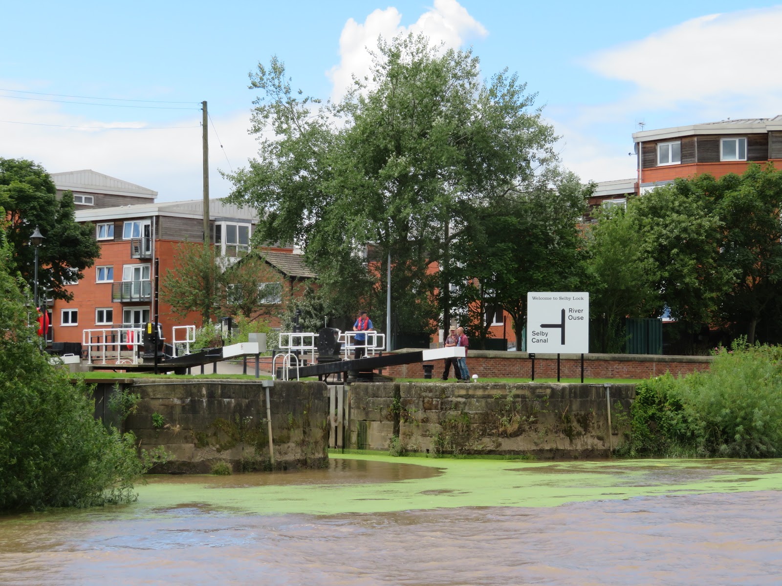
Once through the by-pass bridge the Selby Abbey comes into view along with the rail and road swing bridges. What doesn't make itself apparent is the entrance to the canal system via Selby Lock. However there is a little seasonal clue to it's location.

As we progressed down the reach the sign comes into view. The clue was the very green duckweed that has obviously come from the canal.

As we drew level we could see the lock keeper and a fair few gongozzlers awaiting our arrival. The tides are just coming of springs so despite there being a bit less than an hour to high water here in Selby it was still coming up strongly. I started to swing to port about now to stem the tide.

With it being HW I didn't have to worry about any mud bank that may have accumulated at the down stream corner of the lock and just edged my way over to the lock before steering in, then a bit of a burst on the engine to ensure that the stern came round and we were out of the stream and settling into the lock.

The lock keeper operates the lock for you and as you can see, unlike at Barmby, we are going up in the world, rather than down. The duck weed is very thick and it is quite amusing to see the birds, sparrows and blackbirds, hoping about on it looking for food. It must be like kids on frozen lakes, but not as cold!

A nice toothy grin from Helen as we leave the lock and are on canals again. Her first job though is the swing bridge ahead, over what seems to be a busy road.

It is busy and Helen manages to hold up a fair few whilst I get through. Luckily though the bridge operates smoothly and the delay is minimal.

The old bridge keepers hut still stands as do the windlasses that were used to open and close the bridge. I wonder if they can be still brought into use in an emergency?

We didn't have very far to go as we were leaving the boat in Selby. I was told that they no longer sell diesel or gas, but I did not confirm this but will try to remember to do so when we go back. We had a bit of work to do before we could get along side as the duck weed just rucked up between the boat and the berth and we couldn't really get close. It took me about 15 minutes trying to move the weed away enough so that we could at least have fairly tight moorings. This was accomplished and we were soon all sorted, car loaded and off again. Our one night, two days, aboard seemed like a whole week when we got home. We do love being on the boat, and this going backwards and forwards is certainly a bit of a pain, but as it is just for one year and mainly caused by Hull's year as City of Culture, a once in a life time experience, we are happy to do it.

Thursday 20 July 2017

Out on the Ouse.

We woke up to a fair wind blowing along the cut but otherwise a nice day for another adventure.

The pontoon at Barmby is very quiet and we slept very well. I had a few jobs to do like water etc but had time as the tide time for our departure would be about 1100.

We watched this barn owl hunting this morning. It must have some young to be out in broad daylight and it had been a dry night too. It is always a pleasure to see them in action.

I walked over to the control cabin to have a word with Rob and confirm the time he wanted us. I took this photo to try and show the back wash at the right hand corner of the approach to lock but it doesn't come out too well. You can see a little of the current and winds waves on the river itself though. The lock is quite small and the other side of the wooden piles below the walkway on the left is the weir so it is important that you don't get them mixed up!

The grounds of the barrage are kept beautifully by the barrage keepers and it is a nice place for a walk. The Transpennine footpath runs over the lock too. I had been trying to contact the lock keeper at Selby but we seemed to keep missing each other. He now called me back and suggested that I arrive at Selby about 1230. I was now booked out from Barmby at 1100 so I would have to waste a bit of time on the passage.

We are once again in the lock, with little room, and nowhere to moor up to. Mind you they are very gentle with the ingress of water. We would be penning up into the River Ouse and off once again into a tidal river. It seems to becoming quite routine now.

Helen must be getting used to it as she is smiling so obviously a lot less apprehensive than when we penned out of Keadby Lock on the Trent for our trip down the Humber to Hull (City of Culture 2017, if you didn't know). The water seems to be rushing past, more noticeable due to the bits of tree that are being carried along with it.

The speed of the river meant that as soon as we were lined up after turning out of the lock I was down to tick over. In fact when ever there was a straight I went into neutral and just drifted up with the tide, just using a little chug ahead to straighten up. Dominating the skyline for quite a distance is the 120' spire of St Mary the Virgin church in Hemingbrough. The church originates from the 12th Century and the spire was added in the 15th Century. Up until Henry VIII's dissolution of the monasteries it was a minster church. It has some beautiful wood work and is said to have the oldest misericord in the country. This is a little 'tab' on the bottom of a fold up seat in the chancel of a church that even when the seat is folded up the 'tab' allows minimal support for the a standing figure during long periods of prayer etc.

As the River Ouse twists and turns different aspects are presented and the white prominent water tower at the north end of Hemingbrough village shows itself. It was built in 1958 to boost the water pressure in the public mains. The angle of 'Holderness' shows we are just drifting up sideways with the current. The sharp bends in this area are called Hope's I wonder why?

At Newhay the river makes a big bend of about 160 degs., from almost north to about SW and you can see both legs of the river, either side of the ness in the picture. A little like a bigger version of the Swans Neck on the River Avon. I'm not sure whether this is Hemingbrough Hope or Upper Hope.

The river from Barmby has been quite wide, and with the tide been quite high we have been able to get extensive views. There are several farms close to the river but there are few roads that come alongside. The tide was still burbling up with many ripples and eddies. It was quite interesting to see the way the main current followed the outside of the bends, but on the inside debris got marooned in the slack water behind the bend. You certainly have to be aware of the set of the current, particularly when just dawdling like us.

Looking to the south east as we pass down Barlow Reach you get a picture of Drax power station seemingly hiding behind a Teletubby mound. I assume that this will be ash etc rather than anything else and must look better after it has been landscaped.

The river is lit with light beacons. They are generally on the outside of bends but also in the middle of longer straight reaches. They have some nice names such as 'Cherry Orchard', 'Brown Cow', and this one No.28 is called Thief Lane which is at the end of 'Marrowbone Reach'. It would be really interesting to find out how they were given these names in the first place. Also along the bank are kilometer posts with the distance from Naburn Lock.

The tide was still coming in quite strongly and as the Selby Lock keeper had told me we would pen up towards high water I continued to dawdle along, enjoying our time on the Yorkshire Ouse.

Wednesday 19 July 2017

Weed, wildlife and worship.

Well we are back aboard for a short stay to move the boat to fit in with tidal windows and our City of Culture commitments etc. We left her shut down in Melbourne Basin up the Pocklington Canal. And we found her in the same place, none the worse and with all the batteries fully charged. It was just a matter of decanting the stuff from the car into the boat, including Macy the cat and Skye the budgie and we were ready for the off. The Trip boat 'New Horizon' was just starting load up her cargo of school kids to take them on a trip down the cut, and they thought it would be best for them to go first.

The trip boat has cleared the swing bridge so I left the berth with a little to and fro'ing to get the bow round as the water was shallow to the right of the boat so I had to touch the bow on the bank then reverse and then move the bow a little more to st'bd a couple of times until I was round. Such a lovely spot to leave your boat and sad to leave.

The long arm of C&RT extends even to the backwaters of the Pocklington canal as this lady talking to Helen was conducting a survey of all tow path users to get their views etc.

It seems that the school kids were each being given a chance to steer and I must say they were well wide of us when we passed.

Helen putting her back into closing the swing bridge behind me.

We saw several hares on our trip today, but these were the only ones that allowed me to get a quick snap of them.

I noticed a field of cattle that not only had their ear tags but also a tag in their 'wattle' or what ever you call the equivalent on a cow (or more likely a bull by the look of it). It seems the tag in the beasts right ear is the official primary tag. This has to be yellow and have the crown on, plus the country ie. UK, the herd mark and then the identifying number that is comprised of a check digit and then the individual number for the animal. The primary tag can be in either ear, but in the other ear has to be a secondary tag. This can be any colour and it may be used to help identification at a distance, such as a different colour for each year. It must have the same information is the primary tag but can also have other management info on, so long as it doesn't obscure the primary information. I think the tag in the wattle is an electronic item that may be activates a counter or opens a feed bin or something like that as it seem to carry one number and is not in the ear!

Despite the weed still being quite bad we managed to go a little faster today, and we actually completed the run to Cottingwith Lock in almost two hours less than on the way up.

Here we are at Cottingwith. The by wash was running into the river and wehn we dropped down the gauge was showing just into the yellow caution zone. It was only about 2" higher than when we came up. You can see the sleeve that is chained over the shaft of the paddle gear to prevent it being used without the use of the Waterways Key.

A branch had come down from the low tree in the channel so we had to push that out of the way to exit the short, shallow cut into the River Derwent proper. You can just see the small partially obscured sign declaring that you have made it as far as the Pocklington Canal. Luckily there is only the one large'ish tributary so even if you miss the sign you know to turn right on the way up. 

Just behind the levee is the village of Thorganby and you can see the New Hall in greyish brick to the left. It was built in 1822 for John Dunnington Jefferson who bought the estate an manorial rights in 1812. He built the new Hall to replace a smaller brick built one. In the background can be seen St. Helen's church. The top of the tower was built in the 15th century and the bottom in 12th century. The rest of the church, unseen here was almost completely rebuilt out of brick between 1740 and 1770. It looks a pleasant village with many lovely houses.

The church in Ellerton, on the east bank of the Derwent, has quite a history. It was built on the site of a Gilbertine Priory that was established in 1203. The church, St. Mary's and St. Lawrence's, was extensively rebuilt in 1840, but by the 1970's population of the village had fallen and it became redundant in 1978. In 1984 the contents were removed and the beautiful medieval stained glass was removed and placed in a window at Selby Abbey. The building fell into general disrepair with part of the roof caving in and trees grown in the walls and graveyard. Just before it was slated for demolition the Ellerton Church Preservation Trust stepped in and bought the place. They have lovingly restored it and now use it as an arts space where concerts and exhibitions are held. It must be very peaceful on the edge of the village and overlooking the Derwent Ings.

A little further down stream we came to North Duffield Carrs which are part of the Lower Derwent Valley Nature reserve and we were pleased to see a flight of lapwings. They appeared to be young birds as they wanted to stay together and didn't seem to have the crests of the adult lapwings, or pewits as I know them.

I think these birds are Eurasian oyster catchers but are found all over Europe. They were confined to coast perviously be have spread in land to breed before returning to the coast to overwinter. They are striking birds with the big orange beaks and red eyes.

The next village to the south on the east bank is Aughton. Just about all that can be seen of it from the river is All Saints Church. It is an historic church with associations to Robert Aske who was the leader of the Pilgrimage of Grace in 1536. This was an uprising against the changes that Henry VIII brought about with the Church of England and making the church established. He was was beheaded following capture. His son built memorials to him in the church on the tower, including the carving of a newt or salamander as the old English for it was an ask.

Once we arrived back at the pontoon near the barrage we felt we deserved a treat and had decided on a meal in the Kings Head.  On the way through the village we have meet these guinea fowl that seem to live a charmed life as they dash backwards and forwards across the road. It is a good job there isn't much traffic.

On our way up we stopped at the Kings head for a drink. We liked the look of the menu and determined that we would eat when we passed outbound. There is a good selection on the menu, including a tapas menu. They do take away fish and chips, but Helen had them eat in. She was mightily impressed and declared them superb. I had chicken and leek pie that was very tasty with piles of chips and veg too. I would recommend a small lunch if you are going in the evening!

All was peaceful on the pontoon when we returned, with a lovely sky and the 'traffic' lights for the barrage glimmering on the paintwork of the boat. I hope it is as peacful in the morning when we leave the Derwent

Tuesday 11 July 2017

Well worth the effort.

Once through the bridge it was hard a starbr'd into the Melbourne arm after a pretty long day.

The corner for the turn is a little shallow so it took a little backing and filling to get round and then a little look to see where we were. You can just see by the two birch trees above there is a short landing that is for the lock and not a mooring. They are a little further down.

You can see the purple boat that came up ahead of us on one end of the 48hr moorings and the trip boat is on the other end, where the water point is. We had spoken to people from the Pocklington Canal Amenity Society (PCAS) and had been offered the use of the permanent mooring of a boat that was out for their summer cruise. To access it we had to go to the end of the arm, to the winding hole, and turn, come back and then back into the spot.

The trip boat was getting ready for a trip with a WI group. It was a lovely day for a cruise and we could hear the chatter for a long time after we lost sight of them. The basin has a few reeds and weeds but our berth was deep right to the edge. The water is full of fish of all sizes, with some very big ones chasing the smaller ones, causing regular ripples as they jump out of the water to escape. There are dragonflies too. The permanent berths have several picnic tables and I had a chat with several of the locals. We made use of the sanitary station that was nice and clean and close by. All in all a lovely spot for a mooring. The tow path side was busy with walkers and runners etc but the other side was very peaceful. There are trees surrounding but there is a good view of the sun for the solar panels for much of the summer day.

After our long trip up to the basin and being thwarted in eating out at Barmby the previous evening we made a bee line for the Melbourne Arms about a five minute walk from the basin. It is a former coaching inn and was serving some nice real ales. We had a marvelous meal that hit the right spot, nothing too flash but well cooked and presented at a good price. I would drive this way for another meal sometime. The place was busy and that must be a good recommendation too.

The Beeches on the main road is a lovely Georgian house with a beautiful aspect. It has a stone saying 1790 in the pediment. It is listed as Grade II. It has sold for around £645000 a couple of years ago. The street is full of interesting buildings that show that the village must have had a fair bit of money at the time.

There aren't many of these corrugated iron churches left now and this one is a listed building despite being a private residence now. It is the former St. Monica's that was built in 1882 by the Windsor Iron Works of Liverpool. It is made of corrugated iron and sheet iron on a timber frame. Many of the details have been saved externally and it looks in very good nick. There seems to be getting on for 100 left in the country in various states of repair. It seems that a 400 seat church could be delivered in lots to the nearest railway station for £360. Corrugated iron was first used for roofing in 1829 and full buildings started in 1832. The portability of them meant that many were sent by ship to all parts of the Empire but few are thought to remain abroad.

Our time for walking on the footpaths and bye ways of Melbourne were limited as we had to return home but the effort of getting here was well compensated by the lovely basin with the fish swimming and birds singing and one of the most tranquil moorings we have had. The walk to the canal head would be rewarding and the mile further to the market town of Pocklington and the Burnby Hall and Gardens and Museum close by would also be well worth a visit especially at this time of the year as the gardens have the largest collection of water lilies in Europe. If possible though your journey would be eased by an earlier or later visit when the weed growth is not quite so great. 


Monday 10 July 2017

Puffing up the Pocklington.

As we rose up Cottingwith Lock we could see that there was plenty of growth in the canal ahead. We had been warned several times that there was a bit of a weed problem on the Pocklington Canal at this time of the year. The advice had been to stay in the middle and go slowly, with the occasional bursts of astern to rid the prop of green stuff.

We had been lucky in that a smaller narrow boat had gone on ahead of us. The advice to stay in the middle was easy to follow as there was an almost clear route, at least on the surface to follow and hopefully that would be the deepest water. It is amazing to think that despite the Derwent not being tidal since the barrage was installed the area round here still floods as the water level is raised for wildlife and flood elevation that can mean that Cottingwith lock is under water too.

In a little over a  mile comes the first swing bridge, called No.1 swing bridge, which is pretty descriptive. I think that the sides will drop down if a large low farm load has to cross. The require a waterways key and a lift of the latch before they are easily and smoothly moved out of the way. The second swing bridge, called No.2 swing bridge is just out of sight.

We were thinking that the weed wasn't that bad really, nothing that a good jag astern wouldn't fix every now and then. That was until after No2. bridge. We seemed to stop dead, and no amount of to'ing and fro'ing would move us. I ended up down the weed hatch twice to remove this blanket weed that just jammed up the prop. It  was a very short stretch where the blanket weed was just too much to ignore. I wont say I panicked but I did wonder how long it would take us to get to Melbourne if the rest of the way was like this!

It was a good job we were only able to go slowly down this section as there were several of these rafts moored by the bank. On the top it say 'Water Vole Survey. Do not remove.' It seems that a water vole runs a territory that includes between 30 and 150 mts for a female and 60 to 300 mts for a male. To mark that area they use droppings in a latrine area. These areas are like flat patches of bank or stumps etc. It seems that these rafts are moored as substitute areas that can be easily monitored from the bank. and placed at roughly 10m distance in the area to be checked. They are then checked periodically and the more droppings the more active the water voles are. Once the number of droppings are recorded they are swept off waiting for the next check. Quite an easy way to get a feel for the number and activity of the water voles. I didn't see any droppings on any of the rafts so hopefully they had just been to check them and swept them clean.

Hagg Bridge is Grade II listed. It was built by George Leather who also worked on Goole Docks and the Knottingly and Goole Canal and has the main span and a smaller span over a stream to the left. It also marked the limit of the extreme blanket weed. After the bridge there was only stuff that needed the occasional burst astern to clear. However we did not encourage the accumulation by going quite slowly at all times. There had been a water tap on the other side of the bridge to the right but this has been removed as it was often under water in the winter and it's cleanliness couldn't be gauged.

About a mile further on from Hagg Bridge is Gardham Lock. It is unusual as it has a swing bridge right in the middle of it's length that you can see is open in the photo above. After being restored in the 1970's much of the structure had to be replaced, although the coping stones are original. This meant that it couldn't become listed at the same time as the other locks and bridges were. However since then it has been listed in it's own right.

Above the lock is the weed cutter 'Shelia Nix'. I had been told that at the present it is waiting for a new drive chain. As the chain is fairly unique it is very expensive and is also a regular problem. This explains why the boat is laid up. It is named Shelia Nix after a lady that was a lifelong canal enthusiast and a founder member (1969) of the Pocklington Canal Amenity Society. She was awarded an MBE for services to canals in 2000 and died only last year aged 96.

Looking back at the lock it makes a great picnic spot. There are very few roads in the area and it is lovely and quiet. We have seen several kingfishers dashing backwards and forwards and there are many dragon flies skittering along the canal too.

I think the presence of trees may help prevent the build up of the blanket weed as it will shade the canal and help to keep temperatures down. However I think that the main reason the canal is clearer of weed above Gardham Lock is the fact that the trip boat from Melbourne Basin comes this way regularly so keeping it down. It is a great shame they can't extend their trip  to past Hagg Bridge!! 

In the distance are the Howardian Hills. These are named after the family that still own the land, the Howards. The area of about 70 sq. miles is designated an Area of Outstanding Natural Beauty and seperates the Vale of York from the Vale of Pickering and at 170m high are the out layers of the North York Moors.

Baldwin's Bridge was originally a swing bridge and like all the swing bridges on the waterway it was replaced by a fixed bridge. 6 of the eight have already had a swing bridge put back in position. This one No.5 had the deck raised in the 1970's when restoration started and raised again to 8' later. No.4 bridge is normally left open.

We are getting close now and this bridge No.6 is a farm access road. All the bridges are easy to open so Helen is happy to jump off to operate them.

Almost there now. The entrance to Melbourne Basin is just the other side of the bridge. Not the sides of the bridge are different to the others. They can be lowered to allow passage of low wide loads. This bridge has side that are angled outwards to allow for this already. We arrived here at 1830 having left Barmby pontoon at just before 1000. That eight and half hours is put into prospective when you think that we traveled from Beverley Beck, down the Hull and up the Humber and Ouse to Barmby the previous day in about 8 hours. A distance of near enough 50' against about 15'!

It was slow going okay but it was a lovely day and the views were good and the wildlife kept our interest. I'm not sure what I would be writing now if it had been raining all day. You will have to find out tomorrow if it was worth it!!