Total Pageviews

Thursday 27 February 2014

Snowdrops, aconites, crususes and menhirs. (Not all plants)


Sunday was a lovely day and we had organised to go to Thorpe Hall to see the snowdrops and aconites with some friends. Thorpe Hall is by the village of Rudston which is close to Bridlington at the foot of the Wolds. The owners of the house open up the grounds once or twice a year for the public to see the said bulbs and then later, less often the daffodils. It is all to raise money for the Rudston Church, All Saints. This year the walk was spectacular with many more than I can remember. My favourite though are the aconites, bright yellow flowers that spring from a ruff of green leaves. They look at their best just before they open as the are spherical then. Everybody involved is always chatty and helpful and with tea and cakes on offer what is not to like. Five or six years ago we went for the first time and nearly didn't make it as there was snow laying about, deep and crisp and even. We struggled to get there but we were so glad we did as they looked gorgeous poking out from the snow.

Aconites at Thorpe Hall a few years ago.

Snowdrops this year at Thorpe Hall.
http://thisyorkshirelife.blogspot.co.uk/2011/02/snowdropssnowdrops-everywhere.html

The is Grade I Listed but is pretty well run down at the moment. The house was being taken over by a new family memember and they seemed young and energetic and just what the place will need. The house was built in the mid 1600's and the main block in 1740. In 1773 it was gifted to the Bosville family. One of the later daughters married Alexander MacDonald who was connected with the Irsih Barony of  Sleat. In 1910 the then owner won a court action  to be declared 14th Baronet, 21st Chief of Sleat, 6th Lord MacDonald of the Isles.

After our tea and cake we set off for a walk and ended up on the Roman Road where some of David Hockney's latest pictures were painted. We were soon back down to the village of Rudston and visiting the churchyard of All Saints Church. This also has a famous rock in the yard. It is the tallest tallest, over 8m, monolith in the UK. It is thought that there is the same below the soil also. The rock came from about 10 miles away, some say 40 miles,  and was erected about 1600BC. It is also said that some of the indentations in the rock are actually footprints of animals from when the rock was laid down. They are not definite presently but could well have been. The menhir now has a metal cap on it. As there is another smaller stone also in the graveyard it is thought that when Christianity arrived the top of the original stone was shaped to take a cross piece.
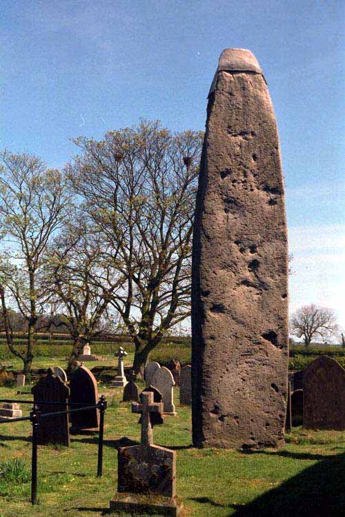
Rudston Monolith
Rudston Monolith.
http://www.rudston.org.uk/

There are two areas of graves for the Macdonald/Bosville family and the stones with their titles carved on make the granite seem along way from the Isles. There is another famous person buried at All Saints. Winifred Holtby's stone is in the shape of a book. Her best known novel is South Riding that was partly autobiographical about living and growing up in the area. She was born at Rudston House, a farm that is still working today. She was born in 1898 and died only aged 37 of chronic kidney disease.

A crusus is a large parallel pair of banks with external ditches that were built in Neolithic times and make up our largest prehistoric monuments. They can run from 50 yds to 6 miles and can have up to 100 yds  between the walls. There are four sets around Rudston. This coupled with the monolith shows that the area was a very significant place at the time. Current thinking is that they were used for ceremonial competions or the like as lots of arrow heads have been found at the terminal banks. Who knows but it took great effort  to build them and move the stone here so they must have meant something very emotional to the people of the time as they wouldn't have given up all their energy to it  when it could have batter been used to hunt and gather to feed themselves.

Plan of Rudston A Crusus.

Rudston A Crusus from the air.
Early photo of Cursus A (after J.K.St Joseph)http://megalithix.wordpress.com/

It is surprising what history there is in a little place like Rudston.

After that 6 or so mile walk we went to a barn dance in the evening and I think we only missed one dance. I certainly needed the walk to get the paper on Sunday morning to get the limbs moving!

Sunday 23 February 2014

Boat time needed.

The weather has been been much more spring like, at least up here in Hull, and we have been out tidying in the garden, the neighbour has been out and actually reinstated their fence that had all but fallen down two years ago and was being held up by the shrubs next to it, and our thoughts have turned to the start of our cruising. The main job we have to do is waterproof the shower cubicle.

I had been thinking of using water proof panels but in the end my confidence in fitting them was not good and once the water got behind we would be in the same position. The current set up is waterproofed faced board. The water has got behind and the waterproof veneer is lifting.

Waterproof sheets for showers etc.

Currently the boards are butted up against the shower tray and so there is an easy route for water between the tray and the boards, especially as a boat will flex at list a little and make sealing this gap more difficult to maintain. We have decided that we will tile the area as this means that the bottom of the tiles will overlap the shower tray so even if the seal is defective the water should go into the tray. I have done lots of tiling previously so have confidence that I will be able to do a good job of it, despite the intricacies of the shape. I have taken advice about the type of adhesive and being told to apply a bonding first. Both the adhesive and grout will have to be flexible to allow for any movement of the panels. I just now have to arrange a few days to live on the boat and get the work done. That is something to look forward to. We have chosen just plain white tiles to keep the area as light as possible.
The current arrangement in the shower. We will be able to do away with the black silicon and the blue boards.

The latest C&RT reservoir watch report is out  and as you would expect everywhere is just about full. The exceptions are the Kennet and Avon and the Huddersfield Canal. On the K&A the reservoirs are 80% which is surprising as this area seems to have had a lot of rain. It seems that the reservoirs in this area don't fill until the aquifers are full so I would expect any more rain to go straight into the reservoirs then! It is still more than 10% above the level of last year though.
IMG_0711w
Crofton pumping station from the Crofton reservoir dam.

The Huddersfield Canal reservoirs are still at 21% of full. This is because of  the reservoir is being kept low. I expect that this is for maintenance or repair work to the dam or other parts but I can't find any information regarding this. As it is the lowest recorded level for February it would seem unlikely 
that it will be full by the time of the boating peaks come about. That is unless the weather stays as it has been for a couple of months now!
Slaithwaite reservoir. The Canal is just off bottom right.

Tuesday 18 February 2014

Where to cruise in 2014.

I was poking about among the C&RT website and came across the Annual Lockage Report 2013. http://canalrivertrust.org.uk/media/library/323.pdf
It made interesting reading. Lockage is the use of a lock and not the number of boats using it as it could be possible for four boats to use a broad lock. However there are figures for the number of boats using certain locks. In general it would seem that the areas we cruised last year were the quiet ones. That suits me fine as I'm not keen on linear car parks at locks and shops etc. What the figures did show was that 2012 must have been a terrible year for cruising as the figures dived compared with the 2011 numbers. I was also surprised that with such a lovely summer as we had in 2013 the numbers did not surpass the 2011 figures. I have read and heard anecdotaly that lots of boats being sold last year. Maybe it is true that the majority of them have been sold to provide habitation in marinas and on permanent moorings rather than get out and about on the system. I would have thought that if anything was going to tempt folk out it would have been the weather last year.

Thinking back to last year I would say out busiest spots would have been the Middlewich Branch of the Shropshire Union, but that was down about 10%. But then we wouldn't have enjoyed the lovely scenery, walks and beautiful sunsets.

Watching the sunset over Church Minshull.

Another busy place was Nantwich with it always seeming to be difficult to find a berth near the town. But then again when we did we discovered a great little town with loads of old buildings and shops and a couple of good nights in the local friendly pubs.

Queens Hotel, Nantwich.

The Shropshire Union to Chester was also busy but the trip to that fair city must be worth a bit of a queue, although we didn't, there were just more boats about. This was in August though so peak season in any year.
In the rock cutting at the foot of the walls of Chester.

On the other hand our cruise around the backwaters of the Midlands was definitely quiet and this was borne out by the figures as it appears to be about 20% down. I loved the 'Curley Wyrley' and the outer reaches of the BCN. Birmingham centre is always a delight for me as the contrast of the busy second city and the quiet canals is great.

I don't look too happy but I love the Old Turn area of Brum.

Over the Huddersfield Narrow was just fantastic and only about four boats moving the whole way, plus a three mile tunnel and a jazz festival in Marsden. What's not to like!

Coming down the eastern side of the the Huddersfield Narrow.

The Aire and Calder were quiet and quite majestic on the river sections. It would be very different in the conditions now mind. The Sheffield and Stainforth and keadby Canals were also lonely places but with the wide open spaces and automated locks were a revelation to us.
Approaching Castleford flood lock.

I hope that were are as lucky again this year. We haven't definitely settled on our route yet but there will be new waterways for us for sure and I'm not sure whether we will make it down to the honey pot places in the south. Where ever we go I am looking forward to it though.

PS. After my last blog, I think it was, I saw a piece in the Sunday Times about Iceland planning to lay an underground cable to export power that they can make in a green fashion by geothermal. This would involve a High Voltage Direct Current cable. This could tie in with the plan for laying such under a new grand trunk canal scheme. As Iceland have a surplus of cheap and green fuel, and are a 'friendly' nation (If you don't count the Cod Wars) it could add a plus for the new canal.


Friday 14 February 2014

Water water everywhere, for now!

Well it seems to have been quite a week of weather around the country. Here in East Yorkshire we have been very lucky and the bastion of the Pennine range has protected us from the worst of the rain and wind. Being in the rain shadow has it's advantages and in 1995 and 2012 we were able to supply water to other parts of the county. Most of our areas water comes from ground water from the under laying chalk aquafier and rivers.  Water was taken by tanker to West Yorkshire to supplement the meagre ten day reserve had in that area. 

Sign of the times: Tankers queue up at Longnewton Reservoir, near Darlington in 1995, when water from reservoirs across the north of England was transported to restock drought hit reservoirs in the south of the country
Tankers loading water at Long Newton Reservoir near Darlington to take south in the drought of 1995.
http://www.dailymail.co.uk/news/article-2123862/Southern-drought-versus-Northern-rain-Reservoirs-Yorkshire-overflowing-despite-dry-winter-therell-hosepipe-ban.html

It wouldn't be feasible to do the reverse with flood water but my mind went to thinking about the problem. Following the drought in 1995 Yorkshire Water became the only water authority that developed a water supply grid that enables them to move water form north to south and east to west and vice versa. They do this using the rivers  and pipelines. Soon only 2% of the population of the area will not be able to be supplied from this grid.

With the current oversupply of water in some areas would it be possible to utilise the rivers and canals to move water away from flooded areas. Obviously pumping would be needed to move the water up hill but I would have thought that it would be possible to generate much of the required energy to run pumps from small scale hydro electric schemes on the rivers and canals themselves. When I started looking at this I came across the Grand Contour Canal scheme of the 1940's.
Posted Image
Plan of the proposed Grand Contour Canal route.
Taken from Eric de Mare's 'Canals of England'.

The plan was proposed by J.F. Pownal and was meant to use the 310 foot contour to bring build a canal 30m wide by 5.2m deep with a head room of 7.6m. Boat lifts would have been used to lower the Contour canal to existing river or canal waterways. Not only would it  bring trade between the places but would act as a conduit for water from wet to dry regions. As it was to be on one level it seems to me to be entirely feasible to move water from wet regions to dry in flood scenarios. This obviously would have been a huge undertaking and was not progressed, even when revived again in the 1960's.

After the last drought in the south the Mayor of London Boris Johnson mentioned that the Pownall plan could be worth looking at again. This led an engineering design company to look at the problem and came up with a new, but similar scheme. This one would have a minimum of locks but basically have the same ideals, if a little smaller dimensions. However it would have the added bonus of several new uses. Not only the movement of water from north to south and the possibility of a transport link, (they state for moving biomass to the power stations), but would also give a pathway for High Voltage Direct Current cables (HVDC) and for large fibre optic cabling. These fibre optic cables would allow the large data centres and servers hubs that are now required to run the internet, and are huge consumers of energy and so generators of emission due to requiring temperature controls, to be moved north where it is cooler. The HVDC cables would be led in the bed of the canal where they would be naturally cooled. The HVDC system seems to have advantages of less loss of energy than the normal pylon AC system currently in use. This would then allow the wind and hydro generated power from the north to be transmitted to areas of use. It would also allow it to be linked up to cheaper transmission lines from Europe to provide a Europe wide electricity grid. The scheme was estimated to cost £14bn and could be carried out in stages. Kielder to Leeds being the first and cost £3.4bn. It would be paid for by tolls from the users and releasing the increase in property prices along the route called tax increment financing. They also suggest that councils along the route would be pleased to have a canal rather than the opposition for HS2. HS" is said to be going to cost between £43 and £80bn so would be a bargain also. It would be a capital project that would not require much external input unlike the building of nuclear power stations.

AECOM's proposal for a canal trunk.
http://www.construction-manager.co.uk/news/aecom-floats-14bn-canal-idea-ministers/?utm_campaign=3+May+CM+WEEKLY+ROUNDUP&utm_source=emailCampaign&utm_medium=email&utm_content=

I'm not sure what this means for moving flood water away from places but it does show that there is scope for thinking big and spending money to make money/save money. It does sound more environmentally friendly than the HS2 and a lot cheaper too.

I hope all those caught up with the floods are safe and  well and will be back to normal as soon as possible. I hope all of you with boats on rivers or other vulnerable waterways have them safe and sound. How long do you think it will be before we hear of a hose pipe ban or then restrictions on the canals due to shortage of water. At least the ground water must be well topped up now!

Monday 10 February 2014

Canals to Colombo.

We have just got back after a couple of weeks in Sri Lanka. We arrived at about 0730 in the morning and almost the first thing we saw was a canal! It seems that when the Dutch occupied the place they realised the potential of using the lagoons and sand bars to connect up together for transport and flood  protection. The British continued this work when they completed the Hamilton Canal in 1804. They made a route from Colombo to Negombo in the north. They also linked the port of Colombo with some canals to move goods in and out of the  capital. They used wooden flat bottomed with blunt bow and stern. They were covered in a canopy of coconut leaf matting. They ere used to bring the rubber, copra and spices from the nearby plantations to the port. They were also used as transport as the roads were not well developed. Actually they still aren't! It seems that they are attempting to bring them back to life by fixing the banks and opening up parts that have been in filled. There seemed to be vast quantities of water hyacinth on the water though. I think the intention is not to use it for transport so much as to make it a tourism facility. By linking with the lagoons there would be opportunities for bird watching, fishing etc. One problem is the newly opened express way from Colombo to airport, just north of Negombo, runs right alongside it.

Padda boats just before WWII.

We stayed with friends in Colombo and traveled in land to see more of the place. Colombo has had very little town planning since Independence and the roads and buildings seem to be just so jumbled that there is constant traffic chaos. There is the new expressway to the International airport and a new express way to Galle in the south and the plan is to connect these up round Colombo, but the rest of the road system is almost country roads to us. This makes journeys slow going as the amount of traffic is horrendous. We went down to Galle and its fort and to see ancient fortresses and rock cut temples and Buddhas, then to Kandy and a couple of nights looking round the Temple of the Tooth Relic and the Botanic gardens and then up into tea country which was beautiful and so peaceful and cool. We also had the mandatory  visit to an elephant orphanage. All in all a great time and nice to have a bit of sun too. We rounded off our trip with a day on the beach at the Mount Lavinia Hotel which was a great way to chill ready for home. It was built as the British Governors retreat but when one of them extended it to accommodate his fancy woman he was forced to sell it to the government. It has a lovely faded charm and lovely views. The terrace is a great place for a sundowner.

Cargills Department Store, Colombo.

Inside Galle Fort.

Pinnawala Elephant Orphange.

Dambula Cave Temples.

Sigiriya, Lion Rock. (A long climb to the top, but worth it).

 Buddha Tooth Relic Temple, Kandy.

Peradeniya Botanical Gardens, near Kandy.

Tea country near Nuwara Eliya or Little England.

Mount Lavinia Hotel, Colombo.

All in all a great place for a bit of winter sun and I reckon we will go again as it was also to get together with my friend and make new friends too. I hadn't bargained on going dancing but we had a good evening out.

Now looking forward to getting away on the boat next month.