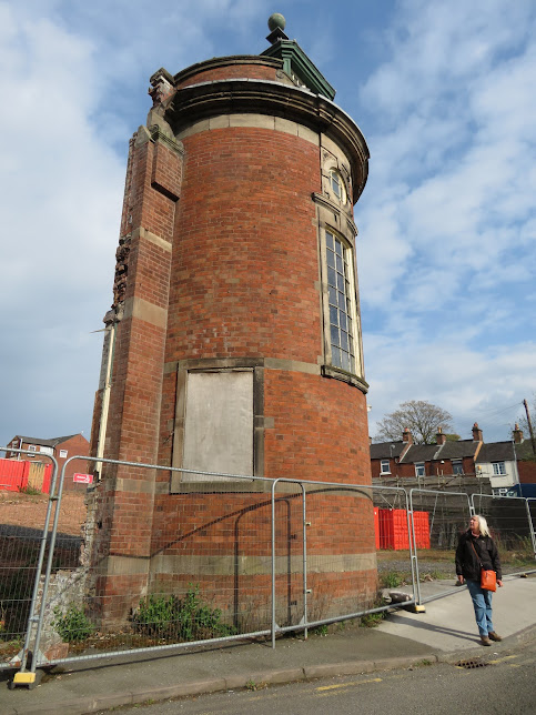
Yesterday we went for a walk into Leek before the rain started and as reported everywhere was closed as it was around.
We were intrigued with this tower that was left from an obviously demolished site. It turns out that it was the old Compton Silk Mill that was built in the late 19th century and was the home of the high class Moorcroft knitwear. The mill behind has all gone but this tower has been retained as the centre piece of a new development of 57 luxury retirement apartments.
Leek Oatcake Shop has been going since 1964 and they are traditionally baked on a massive gridle. I will certainly be back to test them. The bacon and egg oat cake sounds just the jog on a day like today.
Looking down Derby Street to the Nicholson War Memorial, the largest in the country next to Trinity Church. I was disappointed that the Cock Inn wasn't open for a pint of Joules Pale, but never mind, it will taste even better when I finally get one.
The Market Cross in the Market Square is a scheduled Ancient Monument and is post medieval. It was moved from the market place in the 19th Century to the Leek cemetery but was returned in 1984 to be the centre piece. Behind you can see an entrance to the indoor Butter Market that is a revamped Victorian indoor market. The Red Lion next door dates back to the 1700's.
We walked back past Morrison's and B&M and this was the site of the railway station and sidings. Next door was the terminal basin of the Leek Arm. You can see that there were two cranes and a weighing machine in this 1877 OS map extract.
In this photo of the basin from 1900/02 you can see the warehouse with the overhanging gantry and one of the cranes. The white house is still there, much altered I think as there is a building called Wharf House on Barnfields Road. The building on the embankment behind must be the goods shed for the railway. It is also nice to see a narrow boat in the basin.
As it has been raining all day I have had a look at the old map and can see that just down the canal from the moorings, at Bridge 9, where the last winding hole is and on the east side of the canal is shown a rifle range on 1898 OS map. Hopefully you will be able to make out the descending ranges from below the bridge road at 600 yards to the targets right down in the bottom left corner. There was a flag staff to show that firing is taking place. In fact you can see the 800 yards marker at the top right corner. It was said that there was a clear 1000 yards from the other side of the river. In 1859 there was a threat of invasion from the French and there was a rising of feeling to help out the country by rising volunteer forces. Staffordshire was the first county to raise volunteer rifle brigades and in Leek the 28th Rifle Volunteers were raised in April 1860. The range was on Wall Grange Farm land that belonged to the Duke of Sutherland. The range was used until at least 1878.
I took a walk up to the bridge to see if there was anything left of the range to see. I couldn't get on the bridge to look down the range but I'm pretty sure that the wooden post half way up the left had side of the photo is the base of the flag staff. Then between the brick hut and the flag pole is a mound that could well be the bank that they shot from as seen on the old map. The brick built building does not appear on the maps up to 1940, so maybe it is a bunker/pill box that commands the view of the Churnet Valley.
A little further on is Coena's Well (also spelled Cere's and St. Caena's). Following a Royal Commission in 1844, about cities water supplies, The Potteries Waterboard Commission was set up the following year after a meeting in Hanley Town Hall. They tried to engage a noted waterworks engineer, but he was too busy so they took on Liddle Elliot a local man. We surveyed the area and decided that the well would make a great supply of water for the Potteries. The water was tasted (but not analysed) and declared fit for use and better than that supplied at Hanley and Burslem. There is a later pumping station don between the two canal at the junction.
The photo shows a long trough type affair that can be seen on the map above aligned more or less NE/SW. There circular feature can easily be seen from the canal as we passed. It certainly does not have water in it these days, if it ever did.
The Leek Arm is only three miles long but there is plenty to find out about it. I'l look out for the well on the way back down the canal.


No comments:
Post a Comment