Total Pageviews

Monday 30 April 2018

Preston.

Once up the Millennium Link we turned right towards Preston and were pleased to find that there was nobody on the moorings by the services. As it was raining we just sat it out and recovered our breath.

The next day we decided to walk into Preston as we had never been there before, other than on the train. We walked down the canal tow path to the present end. The canal did continue towards the city but now ends in this inglorious end spot, not even a winding hole.

It took about 40 mins to walk into the city centre, past the University College Lancaster campus. We walked through the covered and open markets that had just been refurbished. We bought some local delicacies and stuff for a couple of meals before heading to the Harris Museum and Gallery. Edmund Harris left £300,000 in 1877 to the memory of his father Rev. Harris who had been vicar in the town for 64 years. In 1878 the Preston Corporation opened their first free public library with the contents of the Literary and Philosophical Institute. It was a success so they decided to use the bequest to build a library/museum. The bequest stated that none of it could be used to purchase real estate so the Council had to get an Act of Parliament to do so, and then use the Harris money to construct. It started to built in 1882 and completed in 1893.

The architect was Preston born James Hibbert with Nathan Rainford. It is in the Neo-Classical style and Hibbert had input into just about everything. He designed the pediment was desigend by Hibbert and is called 'School of Athens' but was sculpted by Edwin Roscoe Mullins. The other feature is there are no steps up to the front door from the front but round the side behind the gallery/veranda. Hibbert had great input into the interior and decoration. The main feature is the central hall which is four floors and 120' tall to a lantern tower. It is Grade 1, and deservedly so.

One of the reasons we wanted to go to the Harris was to see an exhibition by Lubaina Himid who is a professor of Contemporary Art at the University of Central Lancashire here in Preston. We came across her at the Year of Culture in Hull when she won the Turner Prize. There was other works on show.  Above is a series of 32 works from 2002 that are patterns that may or may not reflect the label attached.

This is from 2014 called Droened Orchard Secret Boatyard:Tools, box, baskets and hairstyles and were for the Gwangju Biennale in South Korea.

These cut outs are from an exhibition of 1896 called 'A Fashionable Marriage' that is in effect a reworking of an Hogarth picture with Margret Thatcher and Ronald Reagan. It is not my cup of tea but it was nice to see her work in a different setting and with more space around the pieces it was better than when in the Ferens in Hull. We had a cup of tea and cake in the central gallery before hitting Fishergate, the main shopping centre and we both treated ourselves.

Miller Arcade was opened in 1899 and was modeled on the Burlington Arcade in London.

It once houses a Turkish bath as well as shops. It is a lovely building and has some nice shops.

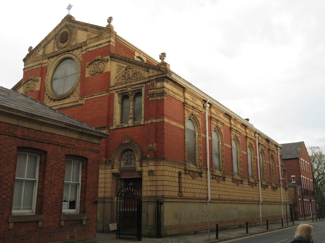
St Wilfred's Catholic Church just off Fishergate looks special from the outside, but gets better the closer you get.

The church was opened in 1793 but these frescos were added in around 1890.


Inside was bright and airy and spacious an well worth seeing.

At the back of the church is Winckley Square that is surrounded by Georgian houses and is a lovely opens space.

These Georgian buildings also house the Society of Jesus who run the church.

After a pint, just to rest our feet you understand we caught the bus back and were soon having our tea.

Sunday 29 April 2018

Who said it is a lock free canal?

Some may have thought that the hardest part of the passage from the Tarleton sea lock to the Lancaster canal would have been the passage down the River Douglas and up the Ribble, or even maybe from the mouth of Savick Brook to the first lock, but each has their own 'interest'. In fact I think that the Brook/canal is tidal to lock 7, but I think that is only at top spring tides, and maybe even with a bit of a tidal surge thrown in too.

We were met at the first proper lock, 8, by no less than three lock keepers, and as there were only two of us going up they would work us through all the way. When there are several lock fulls of boats they have to leave you after the first one to attend to the staircase

If you look closely you can see the stones that mark the spill way into the Savick Brook that can be seen flowing past the mud bank

It is a good job that traffic is one way as there is no room for any more than one. I assume that as the Lancaster is a wide canal they would take wide beams, but I'm not sure.

This is Lock 7, and as you can see the rain has abated somewhat, but not completely. When you come out of this lock you are advised to look behind you as there is the tee for one of the holes of the Ashton and Lea Golf Club. I was pleased to hear that you didn't have to wait for them to tee off, but the warning is just to warn you that some of the balls may end up coming your way!

Now we are on a part of the navigation that does not get inundated so the banks can be hardened a bit more, and it starts to look more like a canal.

I think we are now at Lock ^, or just leaving it. I am enjoying the trip, I really am, despite what my face maybe saying in this picture.

It is obvious that C&RT have been busy over the winter as there has been a lot of cutting back of the trees and bushes on both sides of the canal. We had heard from several people to watch out as we would get caught out by branches etc, but it was all nice and clear.

As you pass under the Preston to Blackpool railway the towpath has been cantilevered on the side of the bridge abutments. I have seen this on a riverside walk in Sheffield and somewhere else that I can't remember where?

After the railway bridge is the Tom Benson Way and the tow path foot bridge. The 'Alessandra' is heading into the lock which is a tight left turn. It is too tight for long boats so the practise is to turn to st'bd and then reverse into the lock.

This is the extended basin which you head into before reversing into the lock. The Savick Brook continues off right ahead, so now the navigation becomes a true canal.

On the deeper locks and the staircase there are vertical risers for you to put your ropes round to keep you alongside. However the ropes do get covered in mud and so does Helen and her coat, and my paintwork! (Or rather the boats!!).

Here we are backing into the last of the staircase. The sculpture above the lock is called the 'Canal Builders' and was opened in 2014. It is by Denis O'Conner and cost around £30,000. It replaces a wooden statue of a naked man with his hands clutched in front of him studying the lock. He was a bit like an Anthony Gormley figure. He was christened the Ribble Piddler, but was actually titled 'Gauging the Ribble'. 

Our companions were heading north as they had to be in Glasson Basin by 1700 on Saturday, and we were going south so we said our goodbyes and went our separate ways. She is just leaving the holding basin at the top of the staircase and out on to the Lancaster Canal proper.

Saturday 28 April 2018

Land fall, but not safe yet.

As we turned round the Astland Light the heavens opened and the River Ribble looked to stretch off in to the murky distance. The alteration of course had brough the slanted rain from at our back to in my right ear!

'Allessandra's' crew were fine under cover, but our conversations with them revealed that they secretly liked the idea of a floating caravan, rather than a floating tent, as was Marjorie put it.

As we sped up the Ribble the tide turned and was just starting to pick up pace a little when ahead I saw a gush of bubbles rising to the surface. I had visions of a submarine surfacing. However I think it was more to do with the nearby sewage farm now that the tide was ebbing!

The green light at the mouth of the Savick Brook was very bright and could be seen right up the reach, despite the murky rain. There is a mud bank to the west of the mouth of  so you need to be aware that you will be set down on to it by the ebbing tide. As we made our approach and got close to the entrance the strength of the tide was deceptive. Just so long as you make sure your transits are opening there is no problem. (Eh, that sounds good, doesn't it!). The white truck is the C&RT man waiting for us. When we were safely in he went to turn the light off. 

Looking up the Ribble towards the city of Preston, (it became a city in 2002). There was an enclosed dock up that way from 1892. Coal was exported that came via the Lancaster Canal from The Leeds and Liverpool and a tramway over a wooden bridge over the Ribble. A massive aqueduct to carry the canal over the estuary was shelved as too expensive. In later years vast quantities of wood pulp were imported as a raw material for the Courtauld's Rayon works north of the city, but that closed in 1981. The docks also closed in that year as the cost of dredging made them uneconomic.

You can see the green light bu the sign on the right hand side. the entrance is well marked with perches on both sides. I wonder if a transit line of lights or shapes would be a good idea, but then I'm not sure how many people would know what they were for, or how to use them.

Almost there, and you can tell how wet it was too.

There is about half a mile of winding tidal creel to follow at the start of the brook.

After a few bends and banks y7ou come to the rotating sea lock. Once we were through we were told to moor up on a pontoon, that was only long enough for one and a half boats. This green light may be the one in the literature that states that it can be difficult to see from the Ribble, because it is!

I wondered why we would have to sit and wait on the pontoon when the tide was falling all the time. I think getting on from 2 foot of water was lost as we waited for the twenty minutes or so. Thye reason for the wait can be seen just to the right of the right hand pile, a low stone bridge. I think we would haqve been okay almost straight away but 'Alessandra' with her canopy would not have made it.

With the tide ebbing quite strongly, although this was pretty much an ebb tide, you had to approach the bends with car so that the current didn't drive you into the bank!

As you navigate the bends this sculpture can be seen. When we first saw it from a distance it looked like a pine cone, than a crow, then a kingfisher, and when we passed I thought a sparrow.

As you can see the Savick Brook is well named a brook! as the tide fell, more of the mud can be seen. I'm not sure how deep it is but after severe flooding the year after it opened in 2002 and again in 2006 the link was closed as there wasn't enough water due to silt. I think they dredge it every year. The whole link cost about £6.5 million to build.

We were still looking fore the first lock as we trickled up the Brook, not knowing what was round the corner.

When we were at Crooke on the Leeds Liverpool Canal we spotted these daffodils and I wondered what they were. Well, Barbara, my mother in law has supplied the answer. It seems they 'Rip Van Winkle'. She also tells me that Hever Castle has many different varieties. Is it the National Collection I wonder?


Friday 27 April 2018

Introduction to Douglas and that Ribble.

We got up a little earlier than normal as we were expecting the call about 0815 with confirmation of our passage. The wind had dropped right down overnight, but it was very grey. James Mayor from the boat yard, and lock master, dropped by and confirmed that we were all clear to go if we wanted. Other than a forecast of rain there was nothing to stop us.

After arrival the day before I had walked up to the lock to see if there were any closer moorings, there aren't. I took this picture from the lock head looking up the River Douglas towards Wigan, to where it used to be navigable before the canal was built.

These are the outer gates on the lock. A pair pointing either way as sometimes on spring tides the water level in the river must be above that of the canal

This is the view from the lock looking in the direction of the Ribble, the way we will be travelling. There was a good flow on the ebb as I was watching.

Boats from the Mayors yard spread from the visitor moorings right to the lock, on both sides of the cut.

Helen is getting an old hand at this business of penning out on to tidal waters, so it was nice to see a smile. Of course as soon as we let go from our overnight spot it started raining, just light drizzle though.

We shared the passage with 'Alessandra' with Marjorie and Robert. They had been over the Link previously and with them obviously faster than we would be, they left the lock first.

We left the lock with a bit of speed so as to counteract the incoming tide and then slowly increased the revs as all warmed up and I checked the temperatures. The mud was slowly being covered and we slowly increased the revs.

About a quarter of the trip from the lock to the Ribble you pass the Douglas Marine yard and long pontoons. After here the horizons open up as the flood bank recedes into the distance and the salt flats reveal themselves

Our companions didn't zoom off to watch out for us. By now I was doing 2400 revs and everything sounded sweet. I checked the temperatures and it didn't go above 180C, so I left it at that.

There was a herd of cows with the freedom of the flats and Helen was kept bust identifying all the birds that were to be seen. There are only two markers left on the Douglas now, the one above, and another further down that was partially collapsed. Not really missed by us today, but on a top spring tide the salt flats would be covered and it would be impossible to know whether you were in the river, or the field!

There were ominous signs astern as we approached the Ribble. The tide was still flooding up, but we still seemed to be doing a good speed.

The flood banks were pierced to allow the river to flood the salt flats on top spring tides to try to prevent flooding of built up areas higher up the river system. After all that is what a river would have done naturally before it's course was constrained to maintain its depth for navigation.

'Allessandra' took the Astland Lamp beacon well wide before turning. You shouldn't go to st'bd of the light as there are mud banks there. If here on a good flood tide you should be aware that you will be set down on to the beacon. The tide was all but shot as we approached, but still had a drain up left in it.

Here was our first objective of the day, the Astland Lamp Beacon, we turned right rounded it and headed towards Preston. As we entered the Ribble, the dribble of rain turned to a deluge. (See what I did there?).

There rest of the journey will have to wit for another day, where you can get many more very grey pictures!