Total Pageviews

Friday 30 October 2020

Is there a Hex of Hexthorpe?

After Stainforth was stopped for a night before carrying on to Doncaster. We were very lucky there was a mooring for us there. Doncaster Market is quite what it was bu there is always a good shop for wool, and a few nice pubs too. Not this time for the pubs though. The next day we set off through Doncaster Prison and out on to the River Don once more. After the busy town and the railway lines it is nice o be out in the country once more

This is the hamlet of Newton and until WWII there was a little ferry just a little past the buildings. It seems an ideal spot and very rural, but this stretch of the river holds dark secrets from the past. In the last 150 years there have been at least 12 drownings on this stretch of water, those that I have seen in the papers of the day that is.
In 1875 a simple lad who was seen around Doncaster selling sticks was found her at Newton.
In 1887 a yound woman had a lucky escape when she was picked up by a passing boat, 'Star of Kilnhurst'. She was just hanging on to a tree by her finger tips, having decided to end it all due to money worries. She found at when returned to her husband that he had paid the money off. She was charged with trying to commit suicide, but was delivered back to her husband.
1907 an apparent suicide as his waistcoat  were found at Hextorpe, on the opposite bank and later a body recovered. There was a note in the jacket saying goodbye to his sweet heart of ever!
Later in the same year another body of a man was found on the Newton side. He had been missing a week.
In 1917 a 23 year old Sergeant in the East Yorks. Regiment had been wounded and gone to recover at a nearby hospital where he had meet a 19 year old trainee teacher who was volunteering there. They had struck up a connection and he had wooed her. He had a fiance at home but wanted to give her up for the teacher. She thought she was too young and wanted to just be friends. Everything seemed to be fine and nobody had any worries. He had asked to meet her and she had told her mother she was going to meet up. They hired a boat from Hexthorpe Flats. The boat was found overturned and the next day the bodies of the couple were found separately. The inquest didn't think anything was amiss and misadventure was pronounced.
In 1919 a woman who was under her Doctor for a nervous breakdown was found off the Hexthorpe Flats. She had suffered very badly for three weeks and had told her daughter that she was better off dead and had nothing to live for.
In 1921 three young men from Doncaster had been tempted to go swimming from the Flats in the very hot weather . They got into difficulties in the treacherous currents and only two made it back to shore.
A 5 year old who was playing with his family on the flats in 1924 fell into the water and although recovered swiftly, and despite trying artificial respiration for two hours was pronounced dead.
In 1926 a man's wife said the the next victim had tuberculosis of the spine and his wife said that at times he was past bearing it and it was cruel to see him so. He must have been a considerate man as he had folded his jacket and left a note before jumping in the water. The note gave his name and address and with instructions to pull the rope. He was found with his legs tied together and the rope looped round he waist.
A 53 year old lady had been missing for over a month in 1929 when she was discovered close to Hexthorpe Flats.
In 1931 a 17 year old lad was bathing on Hex. Flats when he just disappeared. His body was found four days later.
In 1934 a 36 year old miner was swimming off the Flats with his mates when he got into difficulties. 2 of his companions actually managed to grab hold of him but his struggles forced them to let go and he wasn't seen alive again.

It seems that there has been a boat house on Hexthorpe Flats for many years where boats were rented out. The low land by the river here was a very popular spot for games and picnics and bathing, been only a mile and half from Doncaster. The modern boat house belongs to Doncaster Rowing Club, but they have only been in existence since 1989.

A little past the boat house on the way to Sprotborough are these two railway bridges. The first is still in use for freight and the other is now used for the Trans Pennine trail. Whilst we have a blog about death and despair we may as well get over the Hexthorpe Rail Disaster!

It was the penultimate day of the St. Ledger Meeting at Doncaster in 1887. The weather was wet and blustery and there was mud everywhere. Still crowds were flocking to the course. The Midland Railway Co had put an excursion train on from Sheffield and Barnsley to Doncaster. The long train had pulled into Hexthorpe Halt which was only really used for these special trains where they waited to enter Doncaster and all tickets were checked. It was just a wooden platform with a wooden hand rail separating it from the fields leading down to Hexthorpe Flats. Meanwhile a Manchester, Sheffield and Lincolnshire timetabled train had left Liverpool and had passed through Penistone and Barnsley on the way to Doncaster and then terminating in Hull. It had slowed and stopped at red signals but these had changed. The driver was experienced with 20 years and knew the 'road'. He accelerated away and as they came round a sharp bend ploughed right into the back of the stationary excursion train. The Liverpool - Hull Train was doing about 40mph by then but the whole train stayed on the rails, the engine just lost its funnel. The last three coaches of the excursion train were smashed to smithereens. In the end the dead totaled 25 killed and over 40 seriously injured. At the inquest the jury thought that the driver and fireman were the cause of the accident and it was therefore manslaughter. 

Went it went to court the young Union ASLEF were able to hire a very well qualified Barrister to defend their member and after just 40 minutes deliberation they were both found not guilty. The railway companies took a lot of flax for the way they had used mixed signalling. The normal lowering arm of signalling was used mostly across the network by then, but some sidings etc were not covered by these and then they were supplemented with men and flags. There should have been two men with flags and the driver and fireman maintained that the first showed no sign and the second was very ambiguous. Railway companies were pushed to fit all lines with proper signalling. Secondly the rail company was criticised because the engine was fitted with a simple vacuum brake that were not very good and did breakdown. Better braking systems were around but were not fitted in many engines. This accident was the real start of the better systems been fitted to all engines.

As you can see this short stretch of the River Don, less than a mile, has seen much more than its share of death and misadventure. When I was a lad it was always stressed to us young lads to stay away from canals and rivers, and we could swim. In the past only a small percentage of urban dwellers could swim so the death toll would be high, and it would have been good advise then. For me it did make me a 'little afraid' of water, but not enough to stop me having a career of nearly 40 years afloat.


Monday 26 October 2020

Another Lost Waterway.

 Originally Stainforth was called Stain Ford due to the shallows in the River Don, or Dun, in the area. The River Don had a very fractured escape as some went into the Trent and some went north into the Aire and then to the Ouse. In the 1600 Charles I got Dutchman Vermuyden to drain the land better and he cut of the river from the Trent and pushed all the water to flow to the Aire. This caused massive flooding so he cut a new outlet that entered the Ouse at a place that became Goole much later, and this has been called Dutch River. The shallows at Stainforth made it the head of navigation from towards Doncaster and Sheffield. It wasn't until 1726 when the Company of Cutlers from Sheffield started to make improvements in the river at Tinsley close to the city. A year later Docaster Corporation approved work from Thorne to Doncaster and by 1740 the River Don from Doncaster to Fishlake had been cleared and deepened. Therefore Stainforth became an important maritime place. At this time a lock was constructed from the River Don to create a cut from Stainforth to Bramwith to miss out the shallows of the original ford. The river is tidal and as the waterway is very conflicted the currents run very fast.

In 1793 The Stainforth and Keadby Canal was approved and started to be dug from the Trent to join up with the cut at Stainforth. The new canal opened along its length in 1802 but the lock down into the River Don was retained.

Stainforth was the place on the navigation where the masts were taken down and the crane in this picture was used, with masts laid at its foot as proof. The house in the distance was the lock keepers house and the lock was just a little further away.

the Lock house can be more clearly seen in this picture.

The lock consisted of a basin, some of which you can see here, that appeared to have a dry dock off it. The actual lock into the Don would have been at the same angle as the cut from the canal, marked by the stones by the sign, and would be under the trees on the extreme right of the photo.

This is all that is left of the lock down into the river.

By 1849 the Stainforth and Keadby Canal had been acquired by the Don Navigation Company, and a year later by a railway company that after several iterations became the Great Central Railway. This lasted until 1895 when the Sheffield and South Yorkshire Railway acquired the navigation so as to provide competition for the railways. However the purchase price of £1,140,000 was made up of £600,000 cash and the rest in shares of the new company. The railways therefore provided half of the board of directors so nothing much changed. There were big plans to improve the navigation and some work did go on. However it was the opening of the New Junction Canal that restored the connection with the Ouse at the Port of Goole that was the main achievement, although the Aire and Calder Company helped pay for it. It was opened in 1905. This then meant that using the the Dutch River was less inviting as, while shorter, it was much more hazardous.

This is the Dutch River close to Goole. You can almost see the strength of the current and period of navigation would be very restricted to an hour or two either side of high water, and with the differences between spring and neap tides loads able to be carried would be very varied.

In this view we have the wide River Ouse running across the middle of the picture. The Dutch River is the left hand waterway, next widest, that angles of the Ouse and heads up the picture and crossed by Old Goole Bridge and Goole Railway bridge in the distance. The Aire and Calder Canal is the narrower waterway that runs to the right of the Dutch River. The docks and locks of Goole can clearly be seen too.

This old postcard shows the old Vermuyden Terrace that was on the Goole side of the Dutch River just before its confluence with the Ouse that can be seen in the distance. It is taken from the Old Goole Bridge. I like the line of cog boats on the mud flats.

By 1932 there were reports that the lock at Stainforth were silted up and impassable even for a small pleasure cruiser., but by 1937 there were newspaper reports that the clearing and cleansing of the River Don was hoped to lead to industries coming to Stainforth and bring jobs for the out of work rural labourers. However by 1937 it was discovered that the canal company had applied to have the lock at Stainforth disused. When this discovered it was almost too late. It seems that they had to wait four years, and if nothing was done to prevent it, it would be a fait accompli. Thorne and Stainforth Rural Councils quickly got into action to do their bets to prevent it. Mr. Tom Williams Mp and the local members of the County Council joined the other local Councillors in calling a meeting by all interested parties. Several were held. The main arguments were that as the cost of maintaining the lock was very small compared to the benefits that could accrue if the waterway was developed it should be maintained. It was also noted that this was the only toll free route from the area to the sea. Trying to play on the nervousness of the times it was stated that if either Keadby or Goole were bombed it would the only water route from Sheffield, Rotherham and Doncaster to the sea. The over riding feeling though was that it would be a great loss to the heritage of the area. A subcommittee of the Thorne and Srainforth Councils was formed and representation to the County Council to agree to keep it open to be made. In January 1939 there were great flood in the area with 6'7" extra water in the River Don and it over topping Stainforth Lock. The campaign seems to have floundered as by June 1939 the lock was closed and it now forms the basin of Thorne Cruising Club. The Dutch River did remain navigable, certainly near to Goole. Between the Old Goole Bridge and the Railway, on the left back as seen in the aerial photo above, was a factory belonging to Fisons. I remember several ships in the 1990's going up to it. One got jammed in the bridge for several weeks and that meant a very long round trip for vehicles. I think a scaffold alk way was built for pedestrians. I'm glad I wasn't that pilot!

In September 1910 there was a tragedy when three young women and a child along with a dog and a horse were drowned very close to the first to photos. They had been attending a funeral of a man who had drowned near by. They had gone to the home of one of their brothers who was the lock keeper. One of their finances had come to collect them in a carriage to take them back to Thorne. There were two gates before getting to the bridge. He had got out to open them when a scream made him look back and the horse had edged back a little and as the road was very narrow it was in danger of tipping over the edge and down to the river.. Despite the best efforts this is what happened. The horse broke it's neck and as the river was in spate the passengers were soon lost to sight. I young man had heard the screams and he and the fiance nearly lost their own lives in the river and had to be dragged out by others as they were exhausted. The next day the river was dragged and the three women were found not too far away. They were only kissing their hats! One report states that the mother was found with her arms out stretched as if the child had been ripped from her arms. The young lads body was never found. The horse and trap were recovered, the trap with hardly any damage. The dog was never found either.


Tuesday 20 October 2020

A Bridge Too Far, or Too Late!

 Over the winter I intend to use my subscription to the British Newspaper Archive to look out for stories of the past along the route we have traveled this year. Our boat was close by where we live over winter this year. Even so from March we weren't allowed to visit for a good few weeks. We finally got away towards the end of July. Thorne is one the Stainforth and Keadby Canal.

We turned right out of the marina, heading towards Stainforth and Thorne Lock. The first obstruction is the Princess Royal Swing Bridge. This is notorious for not working, but is just a pedestrian bridge. The main road is taken over the canal by the high level bridge next to it.

The site of the high level bridge was the cause of around a decade of disadvantage to the town as in 1921 the Sheffield and South Yorkshire Canal Company banned heavy traffic, greater than 5 tons from using it. You can see below that the bridge, know as the Toll Bridge was a wooden construction and could be swung to allow vessels to pass. Hearings were held over the next couple of years as it caused severe problems for the town. Darley's Brewery in the town had four or five lorries greater than this and these had to unload at one side and have the stuff carried across and reloaded. Thorne Rural district Council had a road roller for road mending and they had to use the railway to move it from one side of the canal to the other!

Picture of the bridge from May 1925.

The wooden bridge seen from the other direction. It is remarkable how similar the old bridge is to the new foot bridge.

A very similar picture to the last but a little more clear, ans with a keel just coming through the bridge hole.

In 1923 it was agreed that a new bridge was required, it was thought that who was going to pay for it would be the problem. By 1925 things had progressed somewhat and an estimate of £75,000 had been received. However things weren't plain sailing. There was disagreement about what type of bridge was required. West Riding County Council wanted a fixed bridge and the Canal Company wanted a swing bridge, on top of who was to pay for it. The canal company didn't want to pay anything but wanted to control the bridge to ensure priority for canal traffic over the road users. The Canal Company used blocking tactics by not attending meetings and generally being obstructive. By 1927 it had been agreed that the Canal Co would only contribute £1600 and the rest would be found between the West Riding and the Ministry of Transport. However the S&SYCC still wanted to be in control of the bridge!
By 1929 there was more pressure on having the bridge completed as the Boothferry Bridge over the Ouse had been opened and now Thorne was on the main connecting route from the south of England to the docks at Goole and Hull. Thorne Rural District Council were getting extremely angry at the delays caused and had sort permission to build a temporary bridge over the old bridge in 1928. By May 1929 tenders had been received and there was now the wait for permission to commence from the Ministry of Transport in London. By September 1929 construction had started. The old bridge was moved bodily to one side to allow the new bridge to be built on the original site. The bridge finally opened in October 1930! It sounds as if nothing changes as the new bridge was only single file traffic!!. It seemed to break down frequently as it was operated by a rope and pulley affair and the ropes came off the pulleys often. It seems that usually this didn't take the bridge men, who were in their hut by the bridge, more than fifteen minutes to fix.

The Princess Royal Bridge seems to have similar problems of reliability but we had no problems on this occasion. 

When we lived in the Midlands we had to come to Hull to visit relatives passing through Bawtry and Thorne and passing what must have been RAF Finningley with the Vulcan Bombers lined up ready for a rapid scramble with their atomic bombs aboard. The route is now a secondary route as the A1M and M18 have become the trunk routes, and the canal passes under the M18 just outside Thorne.


Wednesday 14 October 2020

Making Memories.

 I have been away a couple of days. The first was due to some problems with Blogger I think as I didn't seem to be able to connect with it at all. The next day we were busy with our BSS survey and then I had an evening dash home to pick up the car. We are now at home and that is the end of this cruise, but for the sake of completeness here is our last day.

The days are drawing in and when I got up to make the tea there was the last of the mist on the water looking back to Great Haywood Junction. This was actually Sunday so it was the calm before the hurly burly of a busy Sunday with people everywhere, and boats galore jostling for position.

Looking in the other direction, towards the lock it seems other folk were getting up to make the tea as the fires were being prodded back into life and the sun was starting to warm up the steel hulls too.

Sunday I was busy getting everything ready for the survey and doing lots of other jobs done that I had been putting off. I got the new button put on the stern but forgot to take a photo to convince Marilyn of my handiwork. When the crowds had gone and stillness fell again to the junction we went off for a walk into the gloaming. The Essex Bridge over the River  Trent was all ours. It was built in the late 1500's for the Earl of Essex who lived in Chartley Castle nearby. It originally had 40 arches but only 14 are left. Even so it is the longest pack horse bridge surviving in England and so is Grade I and a Scheduled Monument.

Shugborough Hall loomed over the surrounding fields that were being cropped by quiet cattle in the last of the light.

The Octaganol Temple of the Winds in the grounds of Shugborough was built in 1795 and closely resembles the temple of the same name in Athens. Originally the upper floor was designed as a banqueting room. Later in its life it became a place for the 1st Earl to entertain his gambling mates and the downstairs was used as a dairy. There is also a round stair tower tacked on the side and I love the little portico that apparently closely resembles the Greek Temple. 

Thankfully not much wind tonight so we could hear the geese as they flew to their roost and the tearing up of the grass by the cattle, and a lovely sunset to accompany our evening ramble.

Monday morning was taken up with Steven Heywood going through our boat for the BSS survey. All good other than we needed to bring back our old fire extinguishers. We had lunch before heading off and obviously were at the first lock of the day pretty soon. And the rain started too.

This is known as Shugborough Carrigae Bridge and was built for the family from the Hall to be driven to church directly. There was another crossing the River Trent too. This was built by the Anson family and later than the completion of the canal and iron was used in the ornate bridge.

It wasn't long until we reached Colwich Lock, and this was to be the last of this years campaign, although we may pop out and about for short trips. It is very photogenic from this direction, even on a gloomy and drizzly October day. As always seem to be the case there was a boat ahead of us, and two below.

This carving makes good use of an old tree. The woodpecker can be see through the hole from the other direction. I wonder how long it will last.

Previous to this bridge at Wolseley there was a nine arch bridge of stone that seems to have been badly damaged and the arches repaired using timber. It was an important bridge as it carried the London to Holyhead turnpike road. That one was replaced by this one that was designed by Sir John Rennie and was opened around 1800, with only three arches.

It is a shame to be going home just now as I think next week the colours in the trees will be wonderful. They aren't bad now even. All those leaves that end up in the water and eventually need to be take out again. It is no wonder the old canal companies kept trees well back from the water.

No need to stop for water at Spode House so we just plodded on. The journey took us almost twice as long as I had thought as there seems to be a boat moored around every corner, as well as the 'official' moorings. We met nobody at the oldest 'tunnel' on the Trent and Mersey, Armitage Tunnel. The narrows did form a tunnel, although not along the whole of the length of the narrows. It looks like there is still a short tunnel, and perhaps it is, but it is just a road bridge. (Thought!!! when does a bridge become a tunnel?). The tunnel proper had sunk a bit due to local mining so was too low and in about 1970 the top was taken off to open it out.

We continued on in the intermittent drizzle and Helen was very reluctant to go down inside as it was our last hour or so on a long trip this year. We have taken a mooring at Kings Bromley and arrived there around 1700. we had been told to we could moor up on the fuel pontoon until morning.
That evening I had a taxi into Lichfield and caught the train in to New Street and then out to Doncaster and change for Hull. I arrived home at about 00:45. I was out the house by 06:15 and back at the boat for 08:30 ready to move the boat to our final position and prepare the boat for being left and packing up the car, not forgetting Macy the cat. It is always a sobering time when we leave the boat, but we will be back at the minimum for a bit of peace and quiet at the marina and hopefully given a little fine weather and and a free window, a few days away too.

It has been a funny old year all round, but we have had some lovely boating and some real memories made. With the pandemic we haven't been in many pubs this year so I wont be writing about Beers, Boats and Boozers over winter like last year, but I have had some ideas about what theme to have for my winter musings. Thanks for reading so far and I hope you will check us out to see what is on the blog until we can boat again.

Here;s hoping we all stay safe and well. 


Sunday 11 October 2020

Ranging alongside different rivers.

 Just as we were getting ready to push off three boats came past! But we let go and followed them. There was just one above the lock when we arrived, and when we go to the second lock the first two had stopped at the service that was once the town wharf!

Second lock of the day and Helen puts her back into it after helping the other boat down.

I like the juxtaposition of the original 1770's Longford Bridge with the much newer M6 bridge in the distance. The stretch of canal from Penkridge to Acton Trussell has the motorway running close by that somewhat detracts from the supposed rural idyll as you pootle along.

Teddesley Hall was moved into by the Littleton Family in 1754 after they had had it built. In 1812 the title passed to a great nephew who changed his name to Littleton, but in 1835 became a Baronet and chose his name as Hatherton! In 1930 after the death of the the 3rd Lord Hatherton it finished as the family seat. In WWII it was requisitioned by the War Department as a POW camp for around 200 Germans. After the war it was taken on by the Health Department to become the regional headquarters of the Health Board, but was never carried out. In 1953 it was demolished. This was Park Bridge and you can now see some of the original balustrades that had been hidden by infilled bricks.

It is not only acorns that are in abundance this year as the holly has masses of berries on it. Scientists say these mast years are the reaction of trees to predation. The idea is that the trees keep the production of fruits low many years and this then keeps the populations of their fruit eaters low too. Then in the mast years there is so much fruit that there is more fruit available than the scavengers can manage so more of the fruit can grow. One result of the mast years is apparently an increase in Lyme disease as there are mice and rats to spread it!  

The next lock is Park Gates and this was a entrance to the 2626 acres of parkland that went with the Hall. There was still 1000 acres left when the hall was demolished in 1953, but was largely sold off too.

Acton Trussell was in the Domesday Book and Acton Moat Bridge is named as the canal took part of the moat of an old moated house. Two sides of the moat are still extant and the old farmhouse is the pub part of the very large luxury Moat House Hotel.

Stafford Boat Club must have one of the best setups there is. It seems they started up in 1964 and they managed to restore the Hazelstrine Arm that was built to service a brickworks that opened in the mid 1800's and closed after WWII. By 1976 they were down to three members but a recruitment drive saw them climb to the set up they have now.

The river has been following alongside the River Penk and around Baswich there are the Radford Meadows run by Staffordshire Wildlife Trust. These flood plain meadows are a resource to prevent flooding and are also a habitat for many endangered species of birds plants etc. The flooding brings nutrients for the lush pasture when it dries in the summer.

This signpost is by the Stafford Riverway Link. This is where an arm off the Staffs. and Worcs. to Stafford was constructed in 1816. There was a short narrow 'basin before an iron trough aqueduct over a small watercourse that led directly in to a lock that took the boats down to the River Sow. The locks were the same dimensions as on the main canal. Boats then turned left, up stream for about a mile when they turned into a short arm that took them to a wharf near Green Bridge in the middle of Stafford. It looks like it was disused in 1930's. It would be a nice little addition to the network and bring trade into Stafford too. I hope that it isn't too long before it comes about. River Canal Rescue are based on the industrial estate on the other side of the canal.

Work excavating the basin and the footings of the lock house have obviously started and no doubt the pandemic has put things on hold.

Milford Bridge is a lovely turnover bridge constructed to James Brindley's design. Not quite as beautiful as those on the Macclesfield but makes a good stab at it. Soon after this bridge there are some nice sharp bends to get the canal across the River Sow Aqueduct, stone built by Brindley.

The flood plain of the Sow has not been built on and has been given over largely to wildlife with rushes reeds and water.

The last lock of the day, Tixall Lock, and the rain is coming down. I hide under the bridge whilst Helen closes up. There is still a crane on the old waharf opposite the house on the offside. The house reminds me of some found on the North York Moors. Must be getting home sick.

Rather than a photo of the gatehouse, the only part of Tixall Hall remaining, I would give you a picture of The Wide (or Broad). Stories about this are that the Lord of the Manor only allowed the canal to be built through his Capability Brown designed so long as it was wide enough to look like a lake! Another story is that it made use of an existing lake that was the lake the Izaak Walton learned to fish. You pays your money and takes your choice!

After crossing the River Trent (it looks very different to at Trent Falls, or even Keadby), we come to the end of the Staffordshire and Worcestershire canal and the bridge at Great Haywood that is often the scene of great confusion as people come from all directions and then some trying to get on or off the services wharf to the right. This is a junction on several rings so hugely popular, but today we were on our own. We even got a mooring before the lock so we were 'quids in'.

Once secured we were back in the warmth of the boat and had a bowl of tomato soup. Sometimes nothing else will hit the spot like tomato soup! Once fed it really bucketed it down but has since be dry, but looks like been a damp and cool evening.


Saturday 10 October 2020

Canal Conundrums and Chemical Questions.

 We moored up ans went for a walk into Coven to stretch our legs and came back with a bag of chips to have with our tea. There was even some left for tomorrow's too.

We spotted this oak tree on our walk. I estimated it to be about 15' girth. I think the rule is roughly the girth of the tree at chest height in inches is the age in years. In this case that would be about 175 years. It is amazing that this tree has been here since Victoria was on the throne and Gladstone was the Primeminister.

I thought this maybe a wharf of old between a road and rail bridge at Slade Heath, but it doesn't seem to have been connected with the canal.

A little further on on the towpath was the concrete edge which had had some vertical steel girders at one time, but had been cropped off. It is right near  the railway once again so wondered if it was a rail/canal transfer place. However it looks like it was connected with the construction of the waterworks just the other side of the railway in the early 1960's. I think it may have been too late for coal to have been delivered but it could have brought construction equipment and materials.

I saw this stone next to a spill weir and I thought that it must have been where an old paddle had been for draining the pound but I noticed that it was angled where I would have expected it to be flat. I then thought I saw writing on it and then assumed it must be a mile post. That then made me realise that I had seen no mile posts on the canal at all! I then looked on old maps and can see none marked on them. Why would that be?

The canal winds across the plain and was many trees, but with gaps for views further afield.

We were soon at Hatherton Junction where the old Hatherton Branch joined the canal. This is due for restoration by the Lichfield and Hatherton Canal Society. It would take you to the Cannock Extension Canal near to Pelsall Junction. It is then a short trip round a section of the Wyrley and Essington Canal to Brownhills where it would continue to Huddlesford Junction once restored. That would really increase the traffic round the top of Birmingham and maybe open up the Walsall and other BCN canals.

I thought we were on the Lancaster Canal for a short while as there were warning signs telling you not to stop under any circumstances. This is actually more draconian than the nuclear site on the Lancaster that I seem to remember tells you to move when you hear the siren. The chemical works seems to have originated after the WWI, the early 1920's, with a little factory. The site is now owned by SI Group which is short for Schenectady International. This is a business that was started in the town of the same name in New York State in 1906 making varnishes. Howard Wright was employed by the General Electric Co in the town to experiment which materials would make good insulation materials. This was in 1895 at the start of the electrical age and one of his contemporaries was Thomas Edison. When the boom for products came the in-house insulating varnish unit couldn't cope, so GE proposed that Wright set up a company to supply the varnish. Their products are now used for detergents, fuel and lubricant additives, polymers, resins, fragrances, thermoplastics, antioxidants and fire retardants.

The complex of buildings by Gailey Lock make a very pleasing scene, and with the wharf, chocka with hire boats today is also contemporary with the canal. Helen looks as tanned as the voluntary lock keeper, and he had been on holiday to Turkey.

The Rong House was a toll Clerks office, but this does not explain why round? There used to be a nice little 'canalalia' shop in the ground floor but this is now closed.

This railway bridge marks the area where there was a basin at the end of a tramway from the Cannock and Huntington Colliery. The pit was started in 1877 with 2 shafts, but when they got to 400' they started to flood and were abandoned. Lord Hatherton tried again in 1897. This time they managed the problem leaving No.1 shaft flooded, and managed to add a third shaft. They went through all the levels of coal on Cannock Chase seams and at the highest employed 2000 men. The railway bridge was added as a siding took over from the canal. The pit closed in 1993.

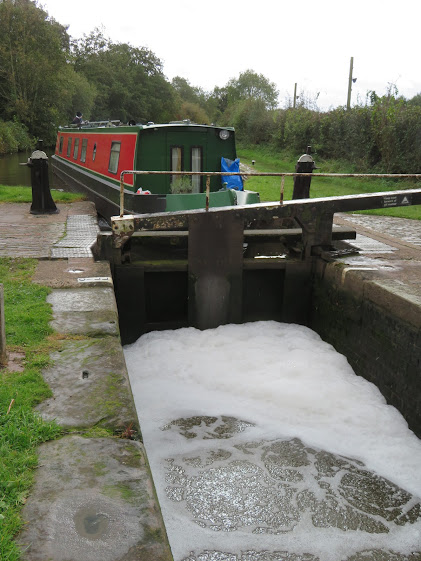
Here we are preparing a foam bath for 'Holderness'. The foam originates when the water has a dissolved organic compounds. This then reduces the surface tension of the water,and when this mix is subjected to aeration bubbles form. It can be natural of man made via pollution. Natural foam has an earthy or fishy smell and is off white becoming brownish. Man made pollution is usually fragrant or perfume like. This lot smelled like new washing.

As we approached Penkridge we came up to the Cross Keys that was still adorned with the M&B signage. I thought that this was from the old brewery that produced such beers as Brew 10 and Brew 11. Thankfully the standard of beer has moved on since then and Mitchell and Butlers have pulled out of brewing, but now they own over 1700 pubs, and this one must be one of them.

We got a heavy shower just as we were coming into the town, and decided to moor up before the first lock. After tea and cake, the rain cleared and we went to stretch our legs to see if the wool shop was open. It wasn't so we came back and put the aerial up for the TV tonight.