It was a nice still night and a lovely red in the sky so we have high hopes for a good day as we were going on another walk of exploration.


Just as it got dark the sun caught the underside of the few clouds in the sky and gave a flash of heat to the colour and hopefully we will have a good day tomorrow.

Just round the bend from our moorings, near Bridge 159 are two sets of coal tips. Round the corner is a one bay store. Here is a two bay. I'm not sure whether that would be two consignees or perhaps two different types of coal, maybe steam and house coals. The coal would be barrowed out of the barge over the tow path and down the tip. The ground drops and each side is enclosed by a wall. The road runs at the lower level so the coal would be largely enclosed, helping to prevent theft, until it was sold on and placed in carts for distribution.

Barnoldswick, or Barlick in local speak, has several sites of the Rolls Royce company. It seems that over a 1000 folk are employed by them and the factories are involved in research and development and construction of jet engine fan blades. The name of some of the engines RB 211 and RB199, apparently the RB stands for Rolls Barnoldswick as they were developed there.

St Mary Le Ghyll church is a handsome church with an extensive graveyard. It is handsome enough to be granted Grade I. The present church was built to replace an earlier church, but that was in 1160 and by Monks from Fountains Abbey too. The tower is very modern though. It was added in 1524!

As we walked along past the church we could hear a horse moving quickly and soon saw a a horse pulling a two wheeled buggy round a fine gravel track. It looked like a training session for trotting races or harness racing as it is sometimes called. The horse never gets above a trot, and if it does it has to slow and pull over in a race. The horses are small and very fit. I didn't know that they held races in the UK so maybe the local farm breeds the horses for else where. Mind you I only saw one other horse on a merry go round getting exercised. They were still whirring round as we passed out of site.

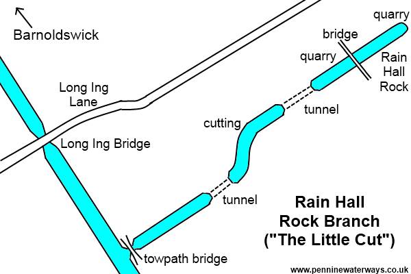
Rain Hall Rock Canal was built off the main line around 1850. As you can see from the plan below for such a short canal, about half a mile, it had a lot of interest. A towpath bridge two tunnels and a very high bridge to get to the quarry where the limestone was dropped straight into the barges. It seems that it closed around 1920. By the canal a mill was built on the site, and in turn has now been demolished. The picture above is the central section that remains.
http://www.penninewaterways.co.uk/ll/ll46a.htm

The bridge and terminus site has disappeared and no trace even of a indentation remains. It has been filled in with refuse and now has a methane collector and burner that is behind the metal railings to the left.

I love this old milestone that was on a little country lane leading from the Rain Hill Canal. It must have been the main route at one time.

On the way to Thorton in Craven and I'm not sure who is the more cautious, Helen, who hates fields of cows or the young bullocks. The views are distant and the sun was glorious.

These alms houses were on the outskirts of Thorton where the Pendle Way and the Pennine Way coincide. Today you would just have a brass plaque by the door. It is nice to think that folk that had 'made it big' in the south hadn't forgotten their roots and put something back. As well as the dwelling they got 3s 6d a week and coal.

This was the view from the front door of Old Cote Farm on the Pennine Way. How could you get tired of that ever changing view.

The stunning undulating landscape of the area is actually a field of drumlins that were formed by glaciers. There are two thoughts as to how these spoon bowl shaped hills, no more than 50m high and about twice as long as they are wide., are formed. Some say that they are from under the ice and they are built up around a rock core that then has sediment etc built up round it. The other idea is that it is glacial till that has been left when the glacier recedes and is then eroded into the shape by flood water etc.
The walk was about 6 miles and the only drawback was there was no pub or cafe in Thorton in Craven! It was nice to have a walk around the area and stretch the legs.
2 comments:
I'm starting to get the idea that we need to do that trip now, Tony and Helen! Wonderful scenery and interesting history abounds all over this country!
M&Dxx
If you haven't seen Yorkshire you have done England, and Yorkshire is a big place. The canal has beautiful parts but been broad means a bit of extra work. If you came up in a pair, or join up when you get here, though it would be fine. You could fit in the Rochdale (or are you too long for the Calder and Hebble). If not, up the Trent to Keadby, you could pop to Sheffield then on the Aire and Calder and then Leeds Liverpool. Have you been to Liverpool itself yet? That is well worth the trip too. Loads less people up here too, and much friendlier than 'down south'. On your way back to the south a visit to Chester is great too.
Post a Comment