In the Trent we had been listening on Channel 15 for vessels that may be moving but heard nothing. As we approached the Trent Falls we saw an outward bound vessel from Goole passing the Apex light and then heard them report to VTS Humber (Vessel Traffic Service, I think) on the same channel. The reporting point is the West Walker Dyke beacon and tide board so as we passed we called them up and told them our name and where we were going and how many aboard. In return they gave us the tide reading at Brough and the Humber Bridge, and then we set off towards the sea.


Some of the buoys are the standard sort like this. As you may know the system of buoyage used is for the red marks to be left down you port (left) side when travelling in the direction of buoyage, and on the Humber that is inbound, or westerly. As we are outbound it means that we should leave them down our starboard side. The tidal gauge reading given by VTS was about 5mts so I knew I could cut some corners and so went the wrong side of some of the buoys.

Because of the strength of the tide in this part of the river the navigation marks are mainly float/boat shaped. This means that the resistance on the hull is less, and so less likely to drag out of position. In fact the Upper, Middle and Lower Whitton Light Floats were manned from about 1909 until they were withdrawn in 1986. Obviously on larger ones than this! The channel round the Whitton's is always changing, and in my day the channel was sounded every week. Cost cutting has brought that down to monthly I think. The channel meanders from the north bank to the south and everywhere in between. In 11 years the channel was hard up to the north bank, then the south bank, but mostly in between. When the channel crosses from north to south it almost has the current on the beam so in order to make the right course you have to lay on an awful lot of leeway, which worries many of the Captains as you end up pointing in the wrong direction!

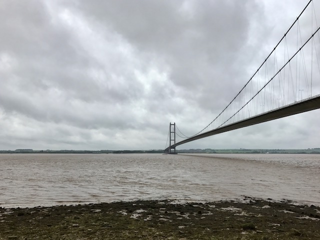
As we head towards the south bank the waves pick up, but there was only the odd bit of spray and nothing like as bad as the Thames when all the fast ferries are knocking about. This was our first glimpse of the Humber Bridge too. As you approach Brough on the north bank there is another reporting point so after checking in I was told the tide gauge readings and still plenty of water.

I'm afraid the skies were pretty gloomy in all these photos, and you get some idea of the strength of the wind from the smoke from the cement factory chimney at South Ferriby, and the waves too. The low lying land below the chimney is actually an island. Read's Island was an old mud bank that was extended by sinking a couple of wrecks to protect it in the 1700's. In 1871 the Humber Conservancy bought it from the Crown Estate and rented it out for grazing. Cattle were taken to the island by barge. There was a shooting lodge and house built on it. When I was passing regularly the channel had shifted and half the island had been eroded. The building was due to fall into the water. They demolished it first as they didn't want it causing a shoal. We regularly saw deer on it that had swum over and now I believe it is a nature reserve.

Once past the east end of Reed's Island and the entrance to the River Ancholme we were in the lee of the land. The river Ancholme is accessed by a lock at South Ferriby. I had hoped to visit this navigation and journey to Brigg, but the Environment Agency has not repaired a lock half way down for several years, and they haven't bothered sluicing the entrance to the lock either. This means that the is a mud wall meaning that only shallow draft vessel could possibly get there at the top of the tide. All along this bank were chalk pits and remains of the rudimentary jetties where keels were loaded can still be seen.

By the time we were approaching the Humber Bridge we were more than 30 mins behind schedule, and I was getting a little worried that we would miss the last lock in. The channel is almost through the centre of the span but to cut a bit of time I cut the corner. The bridge may no longer be the longest in the world, but I think it is still well up there with the most beautiful and graceful. I do hope the plan to build a glass lift up the tower to a viewing platform comes to fruition. It was opened by the Queen in 1981. The designed air draft at spring tides is 35mts, if my memory serves me correctly. There was a class of ship we used to take to Goole that were so big they had a hydraulic top mast that was lowered as we approached. It still looked extremely close as you went under though!

The tower on the north bank was fairly straight forward to build as it sits on rock so only has 8mt deep foundations. The towers are so far apart that, although they are both vertical, obviously, in actual fact the tops are 1.4 inches further apart than the bottoms due to the curvature of the earth! The deck is designed to move 3mts in an 80mph cross wind.

The tower on the south side was sunk into the river and they had to keep piling and pouring cement as it all kept sinking through the mud until they eventually found the rock strata at 36mts. The main wires were then spun in situ by many strand been strung across. The support wires were then run down from them. The deck section were brought out on barges from Hull and lifted up and connected to the support wire, and linked together to form the continuous deck.

Work began in 1972 and it was completed 9 years later. It was the longest suspension bridge in the world for 16 years once opened, and is now the 8th. However it is the longest single span suspension bridge in the world that you can walk or cycle across.
This is what it looked like to those on the north bank that came along to see us pass. This was one taken by my brother Neal. Just to help you out you can see us just to the left of the tower in the distance. It gives you a better idea of the scale. The bridge is now £1-50 each way for a car, and free to walk or cycle.

Once clear of the bridge there is another check point to call in your position with VTS Humber and the channel changes from Ch15 to Ch12. I'm not sure if they can actually track you on radar to the west of the Humber Bridge but there was a scanner at Hull so you could be seen when east of it. I have my hood up not really due to the drizzle but to keep the wind out of my ear!

As we passed the old St. Andrew's Dock lock head, which was the entrance to the fish docks, when we had a fishing fleet in Hull, and was where all the fish were processed and the work down on the trawlers between voyages, we then came past William Wright Dock and graving dock and then to Albert Dock and Riverside Quay. At the west end of Riverside Quay was the old pilot boarding station. Just before I started here there were three pilot services working on the Humber, the Lower Station pilots who brought ships to and from Spurn as far as Hull and New Holland. If they were heading further up river pilots would be changed in Hull Roads and a Goole pilot would be boarded, or else a Trent Pilot. In fact the Goole Pilots were even more specialised as they only worked ships in all the time, or out, never both. So a pilot got very experienced at the operation, and they were quite different too as one was on a falling tide and the other on a rising tide presenting different problems. Just before I started the three services were amalgamated into one and I learned the whole lot. Some small ships felt happy to take on the wide open river from Spurn Point to Hull Roads with no pilot, but would go no further round the Whittons and up the rivers without an expert aboard. Hence the boarding place here. I boarded my first ship as a lone pilot from here. No sooner had I got aboard an old ship with a huge wooden wheel called the 'Egret' than the fog came down at about 1800. It was then I learned that it only had a magnetic compass. They swing all over the place so if you can't see the horizon it is a nightmare to follow the channel. Luckily a ship passed me as I was pulling away so I was able to follow him much more easily. The fog cleared by the time we got to Trent Falls, but the fun didn't end there, but that's another story.
Soon after the Humber Bridge I had spoken to the lock keeper at the Marina and he told me there was only 0.6mts over the cill. My chin hit the floor as there was no way we would get in with that, and us still at least another 30 mins away. I think the waves had reduced our speed and I had actually overestimated the speed increase we get from the ebb tide. He then called back and realised that he had taken the reading as he was lowering a boat out and had got a misreading. There was 1.68 over the cill. There was still a chance we would make it!! I told him I would swing off the entrance and check that we were okay to enter before making the turn into the entrance.
To be continued.
No comments:
Post a Comment