Total Pageviews

Thursday, 3 August 2017

Tourists in York.

Once we had had a bowl of soup we were off into the depths of York. We wandered through the Museum Gardens and near to the main gate was a bloke with several birds that he was charging £3 to be able to handle them for a photo

This little owl certainly looked grumpy about having small kids shrieking in his ears. It was intriguing that it was only £5 to have two birds! I'm not sure that was at the same time or on different hands

Just up Museum Street in the Tourist Information Office and we had a poke about and found that the afternoon free guided walk by the York Guides was taking place shortly so we made our way the short distance to Exhibition Square where it started. Across the road was this nice scene of the Bootham Bar and the Minster. Shame about the bus stop though. There is a knight a merchant and a Holy Man on the top of the Bar that are supposed to depict the different sectors of the City.

The walk was very good as, even though we have been to York many times, it took us to places we hadn't been before. The Viking History was left out so as not to tread on the toes of the Jorvik Centre that has just reopened after floods wrecked the place. Roman times featured on the walk though and here is the Multangular Tower on the old Roman Walls. The small stones at the bottom of the wall are Roman as is the terracotta red strip that was decorative as well as constructional. It formed the west tower of the wall that overlooked the river and would have replaced a wooden palisade. Between this tower and the one at the other end of the wall were small interval towers. There would have been no walk way between them but they could keep an eye on each other and could defend each from the neigbouring ones. In the bottom are stone coffins that were found under an extension of the station. Some have been used as flower troughs in the grounds. The larger stones above were added in the Medieval period but not much is known about them, but they were important during the English Civil War.

In the Museum Gardens are the ruins of one of the wealthiest and powerful Benedictine Monastery in England. It was built by William the Conqueror in 1088 to cement his hold on northern  England. The present day Museum gardens are largely the ground of St Mary's Abbey and had walls all round them that were built in the 1260's. All that is left to be seen is the Nave and crossing of the Abbey church as well as part of the cloisters. It fell into disrepair following Henry VIII's falling out with the Catholic Church over his divorce and the setting up of the Church of England. We took the riches of the old church to fund his wars etc and this explains why we have so many ecclesiastical ruins in England.These days it is the site of the York Passion Play that is performed every four years.

Just by Exhibition Square is the Kings Manor. The original building was built for the Abbots of the St. Mary's Abbey next door in the 11th Century. The earliest remains now are from the 15th Century though. In 1539 after he dissolved the Abbey Henry VIII decreed that it would be used for the Council of the North meetings and it continued until 1641. The Coat of Arms above the door is that of Charles I and you can just see CR below the crown, and the fact that it has the flags and emblems of Scotland and England.

Another doorway on the exterior of the building shows the initials of James I. (at the foot of the door pillars). Henry VIII, Charles I and James I all stayed here.

This doorway is from the inner courtyard that was built around the 1560's probably using stone from the Abbey. I'm not sure what family the Coat of Arms is for but there is a cafe that is now housed in the old Council of the North room. As you pass through this door you are faced with a brick and concrete flat room building from the 1960's as a total contrast. It is strange that it houses the Archaeology department of the York University!

I had a bubble pricked in Exhibition Square, if you will pardon the expression. There is a missing section of wall that was knocked down in Victorian days to relieve traffic congestion. There were plans to knock alot more down too but the locals revolted. They managed to gain assistance form some powerful people. Among them was William Etty, who is remembered in the sculpture. Not only did he use his influence in high places to save the walls, but went further to ensure the walls were kept by building a walk way on them so that they would be used by folk. I hadn't realised that the walkway and the top of the walls were added in the Victorian era. 

This was taken from near the northern tower of the walls. The Minster in the background and the building that seems to be wrapped in plastic is the old Archbishops Palace (I think), and next to it is the Library.

This is the Victorian top of the Monksgate Bar. The figures have stones to drop down on the besiegers below.

This is Chapter House Street and somewhere below is the  Roman Road that led from the gate in the old Roman Fort to the centre of the garrison. It makes a nice picture with the  tower of the Minster in the background. The walk was very good indeed and they are twice a day, plus some evenings and a really good way to see other parts of the City. There are many other walks too that are guided by others and may well give you a more general view of the city to get your bearings.

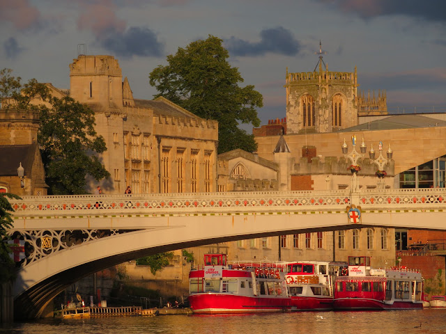
Once we got back to the boat and were satisfied that it was still there, always a slight worry when mooring on a river, especially one that is rising or falling. I had left the lines quite loose so that there was give in the system. In fact the water level had dropped about 6" since we arrived. The sun came out and illuminated Lendal Bridge and the  York City Cruises beyond. The evening light makes the stone look like butter and the bright red hulls add a splash of colour. Usually it is Helen that takes the best photos but this one is mine.

Birthday Girl.

I hope Helen is not too embarrassed by these photos. I have tried to pick ones that she will approve of that have been taken over the six years we have had our boat, and I couldn't let her birthday pass without recognition on the 'Holderness' blog, especially as she actually takes many of the photos.

For our first year we headed down the Leicester Section of the Grand Union, on through the North Oxford and the Coventry to the Trent and Mersey heading for the Caldon Canal. I don't remember any great problems and it was just great to be away together. I think this was somewhere near Barlaston and the Wedgewood factory.

It seemed that we had the Caldon Canal to ourselves. Once back on the Trent and Mersey we headed north again on the Macclesfield, Peak Forest, Ashton and to Manchester on the Rochdale. We then headed off to Liverpool on the Bridgewater and Leeds Liverpool. After a great stay there we headed for Chester and Ellesmere Port. Then back down to Birmingham on the Shroppie before back up throught Stoke and the Macclesfield to get to the Huddersfield Narrow Canal. It was quite an adventure but once again we felt that we had it to ourselves and despite the weather and the bottom being close to the top in places and drained pounds we had a great time as you can see.

We used a marina at Thorne that winter and the next year we up the South Yorkshire Navigations to Sheffield and had a great time there. We must go back soon. We then headed back and on to Keadby and up the Trent to Chesterfield, which everybody should do some time as it is beautiful especially above Shireoak. This is Helen writing up her log as we go down the Keadby and Stainforth canal on the way to the River Trent.

From the Chesterfield we were back on the Trent as far as the Fossdyke and Witham Navigation to visit Lincoln and Boston We then continued up the Trent to Nottingham and through to the northern reaches of the Erewash canal. After that we headed down the River Soar. We had some great weather and Helen is enjoying the sun as she waits for a lock to fill near Birstall north of Leicester.

In 2015 we picked 'Holderness' up again at Dewsbury and headed once more up the Trent and then on to Birmingham. We love Birmingham and no excuse to visit, but luckily it is the major cross roads of the system. Here is Helen at the top of the Balck Delph flight of locks enjoying the challenge of the descent. We ventured on to the River Severn and headed to Glouscester via Droitwich. We also loved the Gloucester and Sharpness Canal. We decided to take a pilot from Sharpness and travel to Bristol, via Portishead to get to the Kennet and Avon canal.

From the kennet and Avon we used the Thames to get on to the Oxford Canal to head back north. We turned on to the Grand Union and here is Helen once again leaning on a gate at Calcutt middle lock with the distinctive paddle gear.

Not only do we love Birmingham but we also enjoy cruising around the Birmingham Canal Navigation with all it's backwaters. Helen loves a map and a leaflet that adds value to a walk and here she is at Bumble Hole, Windmill End, on the Dudley canal No.2 just by Netherton Tunnel taking us on a walk around the nature reserve that was once a hive of industry.

From Birmingham we headed down the Stratford Canal and the River Avon before looping back up via the Severn and the Droitwich to get on to the Oxford Canal to head for the Thames. We did the full length of the Thames from Lechlade to Limehouse Basin anyway. Here is Helen passing as a Lock keeper. It is funny how the people on cruisers don't seem to like to get off them to work a lock when they are on self service. Helen remained calm, usually when she was been asked daft questions, or being told what to do by somebody in white trousers on a cruiser. She certainly looks the part anyway.

The boat had a repaint over the winter and we perhaps did not plan the best route following that as we headed north once again as the City of Culture Year in Hull beckoned. As we are both volunteers we wanted to be close so as to miss as little as possible. We headed down the Wolverhampton 21 and were soon on the Shropshire Union heading north. we had a crew of daughter and partner for this section and here is Helen taking it easy near Tyrley Wharf.

This was at the summit pound this year having made it up from Manchester to the Yorkshire side, well almost. The border is at the other end of the summit pound, and if I may say so, the most beautiful parts of the canal start then too.

We really love our time on the canals and rivers of England and Wales and truly relax. Give us a wave if you pass us.

Yomping to York.

We didn't really get away until near enough 1000 as we were just enjoying being lazy and being back on the boat. Once we did leave we just pottered upstream at canal speed.

Once we left the visitor moorings we were soon out in the river and looking back to see the mill island in the middle with the weir to the right and the visitor moorings and lock cut to the left. All looking down stream.

After passing an awful lot of plastic cruisers at York Marina we came up to the railway bridge. The bridge was built in 1871 and the left hand span was opening to allow the passage of vessels. At that time it was the main east coast track. However in 1983 the Selby Diversion was opened and the route was downgraded. It finally closed in 2000 and in 2002 it became a walk and cycle way and part of the Trans-Pennine Trail.

Local folk decided to raise money for a piece of artwaork for the bridge. People that used the bridge were consulted and several themes and ideas chosen. The one by Pete Rodgers was selected. As you can see it is a wire sculpture that is 3 mts tall and is called the 'Fisher of Dreams'. You can see the angler has his dog with him, who his cocking his leg and with his bike by the side. You maybe able to make out that on the end of the ,line is the 'Flying Scotsman' that used to travel over the bridge in its day.

Bishopthorpe Palace is the residence of the Archbishop of York, the 'second in command' of the Church of England. At the moment the Arch Bishop is John Sentamu. It was in 1226 Archbishop Grey bought the local Manor and from then the village became known as Bishopthorpe. The building was remodeled between 1763 and 1766. It has a gatehouse, brewery and stables and has a beautiful garden and an unrivaled view of the river. In 1830 a vessel from York to Hull would stop here to pick up passengers who would be transferred to a London bound ship at Hull.

 The main trunk road that skirts to the south of York, the A64, crosses the river just to the north and it was extremely busy as we sedately passed below them. 

This is the back of Fulford Hall. The claim to fame for Fulford is that a battle against a Norse Army took place here. The Northern English lords battled against King Harald II and his alley Tostig Goodwinson and lost in September 1066. Tostig was the banished brother of King Harold Goodwinson and it was only five days later that King Harold Goodwinson fought another battle against them at Satmfird Bridge and routed them, killing most of the Norsemen. We all know that after a forced march south to the south coast to repel the invading Normans he lost his life to an arrow and William took the throne.

We saw two 'icecream boats' moored up just before the Milennium Bridge and we later saw them doing a roaring trade up by Lendal Bridge.

The Milennium Bridge was the winner of a competition by Whitby Bird and Partners and was opened in 2001 and cost over £4 million. One of the many York  river cruisers is seen heading back towards the city centre.

The blue bridge to the right is over the second river in York, the Foss. With 2 days notice the local IWA will work the lock for you to explore the short length of it through the city. The River Foss was allowed to flood and it is why there are no city walls by the river as the marsh was thought of as sufficient defence.

As we approached Skeldergate Bridge. The York Cruisers are out in force now. Skeldergate bridge was built between 1878 and 1881 in the Gothic Revival style. Behind the lead boat is a small arch. There is a similar one on the east end but this one lifted to allow boats to sail through with their masts still raised. The tolls were officially abolished in 1914.

The site of the Bonding Warehouse on the west bank of the Ouse in York was once the site of the landings for cargoes as far back as the Medieval period when the Common Crane was sited there to land goods. This building was erected in 1875 and has a vaulted brick ceiling on the first floor supported by iron columns. It is now luxury apartments.

With the dark and gloomy skies contrasting with the local sun Lendal Bridge and the City Cruise boat look good. The tower is Lendal Tower that gave it's name to the bridge. On the west bank is the Barker Tower. Both are Medieval. The bridge replaced a ferry that became overwhelmed when the railway came to York around 1838. I bridge was started in 1860 but collapsed during construction and five were killed. A year later the currant structure was started and the Gothic Revival bridge was completed in 1863. It is now Grade II listed and the original tolls were lifted as early as 1894.

The detail of the bridge shows the white rose of York, the crossed keys of the Diocese of York and then lions of England. Between the lights is the monogramme  V and A for Victoria and Albert. The angels are just for piety I'm guessing.

When we arrived the moorings alongside the Museum gardens were under water but we found a spot at the bottom of St. Mary's Gate just right for us. The only other spot we could have gone to, Queen's Staithe was occupied by boats that had huge gaps between them so we were glad to have a spot to ourselves. We were ready for a trip out into the town after a spot of lunch.

Tuesday, 1 August 2017

Out on the Ouse again.

We got a lift back to Selby from Hull via our son that made things much easier. It turned out that we had to rush a little in the end to get to the lock for the 1300 time that we had been given for our trip out on the Ouse to York.

We paid our dues and then had to wind at the slipway at the Selby Boat Centre. It was a bit breezy so I got the stern in and the wind drove us round and we were soon heading towards the swing bridge. We were soon through that and into the basin. It was full of boats so we sailed past them all and moored up by the lock.

It seems that the river has just come off red boards so there were several boats waiting to make the trip up to York. There were to be two narrow boats ahead of us and then three cruisers astern of us. I went to look at the lock at just before 1300 and the tide was slack. It is neap tides today  and I was able to see the mud heaps that have built up at each knuckle of the lock. Well worth seeing as then you know where not to go when we return this way.

The weed boat had been very busy in the basin and there was not the accumulations of duck weed there had been when we arrived, but there was still plenty out in the river. We are getting old hands at leaving locks into tidal rivers so even Helen was less apprehensive than normal today. We would be taking the flood tide up river but as it was a neap tide and there was a bit of fresh water coming down the current of the flood tide was not that great.

Before arriving at the Selby Railway Bridge there are some wharves that were in use up to about 10-15 years ago. The warehouses behind are nice old buildings and seem not to be used for much. The Custom House Wharf was first built when the canal was opened in 1778. The last cargoes I can remember coming up here were barges of rice from America.

The original opening railway bridge was a double span lifting bascule bridge in 1840 for the Hull and Selby Railway. The present bridge was built in 1891 for the North Eastern Railway and swings open. The control cabin sits above the pivot point and the bridge master popped out to give us a wave as we went through. As we left the lock earlier we saw a cruiser coming up the reach, probably from Barmby. The red stripe is the deck of the Selby road bridge. The present structure was built in 1970. As far as I remember the toll for a car was 2p. The tolls were abolished in 1991. This was two hundred years since the building of the bridge that this one replaced!

Westmill Foods is where the cargoes of rice were brought as they are major packers of rice for the catering trade. You can see the mud on the ness  (inside of the bend) of the 300 deg bend just after the mill. I'm not sure if the red painted struts are original or were added later for stability as if the bend was eroding away.

The sky got very dark adn the river looked like gun metal rather than tea for a while. The sun shining on the backs of the goat willow trees gave a very strange colour to the leaves and makes a nice photo.

Eventually the rain came and what I thought was going to be a little shower turned out to be quite a deluge. It didn't last long and when it past the sun was out once more and I soon dried off.

It seems months since we have seen so many moving boats in a day. There must have been several boats held up at Naburn lock due to the flood warnings as there were eight or nine boats, including narrow boats, heading down to Selby and beyond. The river remained quite wide but did have a good bends in, especially at Turn Head and Wheel Hall

Cawood swing road bridge was undergoing lots of repairs and was closed. The bridge was opened in 1872 and repalced a ferry. It used to be a toll bridge but is now looked after by the County Council. It has a weight restriction of 7.5 tonnes due the nature of the structure and it's age. However vehicles frequently ignore this and cause damage. The bridge has cameras that record traffic that ignore the traffic lights and also register as more than the weight limit and they receive automatic penalties. In the heavy flood of 2015 the river level was above that of the deck of the bridge.

After passing Naburn Ski Club, and in Acaster Marshes Reach we got a glimpse of Moreby Hall was built in 18 above the trees. The last cruiser had over taken us here. By this time we weren't getting much help from the tide as it was just about stopped flooding at the surface. Moreby Hall was only built in 1828 when the High Sheriff of Yorkshire, Henry Preston, married into another landed Yorkshire family and had a new house built it was completed in 1828 and in today's value would have cost over £3 million. It is Grade II listed. In 2014 it was up for sale for £2.8 million!

By the time we got to Naburn Lock we had caught most of the other boats up as the narrow boats that left ahead of us were just penning up. We had to wait out in the river with the last cruiser too. The right hand lock was the first and is no not used as it is very small. It was built in 1757. Before this the island was built along with the weir that is to the left. A mill with a water wheel was built on the island. There are pontoon moorings that you can see below the weir and in a corresponding position above the weir. The large lock was built in 1888.

We finally got in the lock after three hours from leaving Selby. The bridge is opened/closed by chain round a windlass. Consequently is mainly left open I think.

We stopped and filled with water before moving up to the visitor moorings for a very peaceful night. It seems everybody else had continued on to their moorings or to York. Other than getting drenched from the short, sharp shower it was a very pleasant rip up to the tidal head of the Ouse.