Total Pageviews

Monday, 26 April 2021

Sandon Circumnavigation.

 Woke up to another wonderful morning, cool and crisp and sunny. We were off for a walk just after 10:00. We ambled down the towpath back to Sandon Lock and onto the road 
Sandon station was opened in 1849 by the North Staffs. Railway. It was later called Sandon and Salt Station as the Uttoxeter opened another one in 1869 called Salt and Sandon Station! It was built in grand Jacobean style with a porte cochere for the Duke of Harrowby to dismount from his carriage in shelter. At the time he was building a new house at Sandon Park.

At the crossroads with the main dual carriage way are the Village Rooms and cricket pitch. The building was designed by Guy Dawber in the Arts and Crafts style in 1904. He also built a row of cottages in the village as well as the Dog and Doublet pub in 1906, that is just behind the camera. You can also see the Sandon, Gayton and Marston War Memorial that was dedicated in 1921. It is sobering to see that 80 left to fight and 23 gave their lives. They not only fought in France and Belgium but also Gallipoli, Salonica, Mesopotamia, South Russia, Egypt, Palestine, Italy, East Africa and India. A little outside the village, towards Stone is another memorial that is for the crew of a Lancaster bomber that crashed nearby in May 1945. The plane was from 428 Squadron of Middleton St. George, which is now Teeside Airport.

We crossed the dual carriageway and went up the minor road past the gates to Sandon Hall. We passed the school that is undergoing renovation to a private home at the moment. You could tell it was a school as it had bracket for a bell above the gable end. We walked across the field to All Saints Church that was rebuilt in the 1300's The north aisle was added in the 14th Century and later, 1817, converted into a family chapel. The whole church was rebuilt again in 1923. It has a great view and the vicarage is next door.

Down the hill from the church is the site of a moated hall. The moat is stone lined and can be seen easily. It dates from between 1250 and 1350. The original building had more or less gone by 1854.

The photo was taken from the top right corner, you can see the foot bridge that gives access to a house close by, but the original entrance was via a drawbridge to the east. This map was surveyed in 1879 and you can see it had been taken for a summerhouse and fountain.

Up the hill past Stonehouse Farm, another Listed building, and at the top was a great view of the Trent Valley with Cannock Chase to the right and Rugeley to the right of middle. (You can just see the coolling towers).

We then walked through Sandon Wood which has extensive bluebells. I reckon we are a week early as they are just starting to come out, but will soon be a real carpet of them.

Having left the wood and across a field we came to Stocking Brook. It is not true that the bridge collapsed after Helen crossed and we both got to the other side.

Climbing up the valley side again there were several ponds or tarns that came as a bit of a surprise as it has been so dry. The underlaying rock is sandstone and seems to stop the water percolating down. Over field paths you come to a by-road at Hartley Green. We could hear it along time before we got there as they had several peacocks that were extremely loud. The road is where you join the Stone Circles Challenge Way which is a 36 mile walk in Staffordshire that is a circular walk with Stone at its centre.

Leaving the road we follow the Stone Circles route to the rear of Gayton village where there is a ford and footbridge. The Gayton Brook is very attractive. I wonder if the place gets busy with families in the summer holidays?
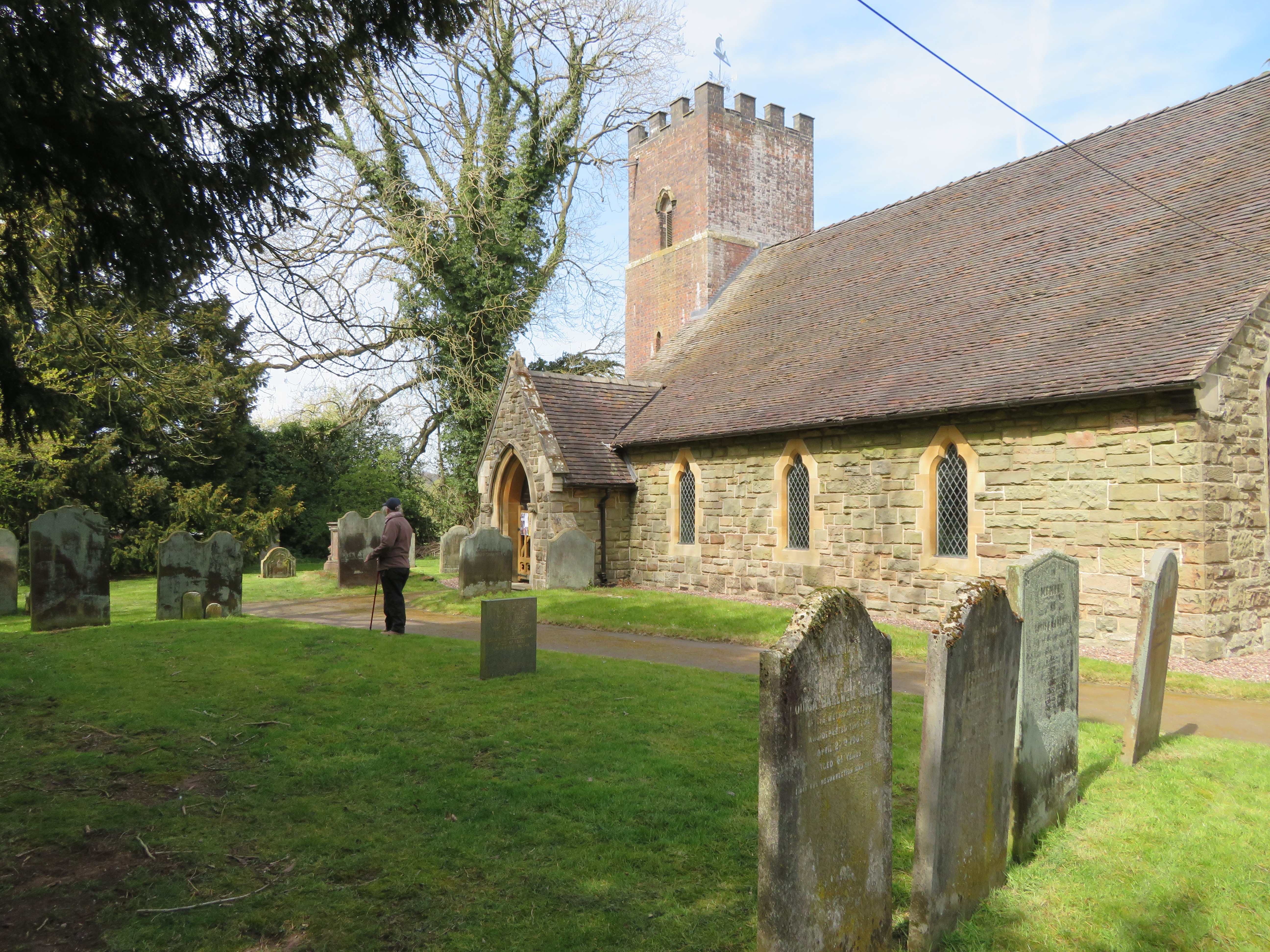
We made a short detour to have a look at Gayton Church, St. Peters. The oldest part of the church dates from 12th Century and the tower was added in 1732, along with internal alterations there was another rebuild in 1871. The graveyard is quite atmospheric.

The route than passes through a wood and watch out on your right and you will see this bridge built on stone buttresses. Follow the rough path  under it and to the left.

And there you will find a mound with this 75' Doric Column with an urn on the top. It was built in 1806 by the 1st Earl of Harrowby who was a good friend of William Pit the Younger, to whom the column was dedicated to in 1806. The Duke was once the second to William Pitt in a duel. Both men shot and missed, and after agreeing that each of them had had their honour satisfied they shared a coach back to London. The pistols are in the main house.

On the other side is an inscription in Latin that has William Pitt's name and the Dudley's of Harrowby, The Duke, Father of the Country and friends. But don't quote me on the exact translation.

After the woods you obtain partial views of the main house from 1852, rebuilt after a fire, and Sandon Home Farm. Back across the main round and down the road to Salt. A little way down you cross the railway line and the canal. descend to the tow path and walk north towards Sandon Lock. At the lock, behind the wall, are the remains of a lime kiln. The kiln is largely intact and is Listed. It is special as it as hints of neoclassical stone work and is an unusual pyramid design. It was built in 1790. 100 years later it is called the 'Old' lime kiln on the map. The brick and wooden building was called a smithy on the same map.

The walk along the towpath back to the boat was quite quickly and back for a cup of tea. It was a great walk in fantastic weather. It would be a great walk in early May when the bluebells are out, but in very wet weather there are places that would be very muddy. Today it was bone dry. Another 6.8 miles walked.


Sunday, 25 April 2021

Salt of the Earth.

 A couple passed us chatting at 0600, and by 0700 the first boat of the day. We supped our tea until 0830 and then stirred ourselves. After breakfast we walked into Great Haywood to get the Sunday paper and back again. We waited for a gap in the traffic and then set off. As we were approaching the Shugborough carriage bridge a lady called from the towpath that she read my blog and kindly said that she learned more from reading it about her local area than form other sources. How nice was that. Thanks very much for reading and your generous comments. There were several people 'wild' swimming in the Trent from the fields on the Shugborough side.

There was a little delay at the lock, but plenty of people to chat to. We were luck enough to get on the water point as often it is a right scrum at the junction, but it all fell into place for us. 

 so no
After dropping off the rubbish too we set off behind the other boat on the water point. I wondered why this family were walking down the tow path with a boat that looked fine. They looked cheerful enough so I didn't think there had been a disaster. It turns out the swan just out of the picture had attacked them and they had got out to avoid him. I didn't see the nest he was protecting though.

Between Great Haywood and Hoo Mill Lock is this old girl. Lily was built at Saltley in Birmingham by FMC for the company in 1914. It was iron composite. It was sold out of the company in 1963 and at some stage it was working as an hotel boat. Apparently it had a fire in 2006 at Blisworth, and damaged the cabin. A good project that will have been knocked back last year when nobody could get to their boats.

Just by bridge 78 are some moorings and it seems that they make/refurbish old travelers vans.

In this part of Staffordshire there was a salt industry up to the 1890's just past the bridge is this area of pits that I suspect is the result of subsidence from the brine extraction.

This is all that remains of the entrance to an arm that fed the Shirleywich Salt Works. The salt was of good quality and had a boost with the digging of the canal. 

It can clearly be seen on this 1880's OS map with a weighing machine at the head of the arm.

Just above Weston Lock was another arm to a salt works and other places. The arm ended just by Ingestre Station.

You can see the brine pit. Coal would have been a cargo brought up by the canal to evaporate the brine, and make the manure. The canal would have been a boost as coal would have been much cheaper when delivered by canal, and transport of the salt away would have been cheaper and easier too.

Bridge 82 is not the normal bridge, but was built to superior standards as it was used by the owners of Sandon Hall nearby.

We didn't go much further and moored up close to this mile post, that is one of the original ones made in Stone by Rangeley and Dixon in 1819. Rangeley and Dixon were a small operation at the rear of the Mansion House on Lichfield Street, and were known for making roller pumps. The company closed down in 1829. We will be here for a couple of days I think. Especially as it seems we have a television picture for the compulsory Sunday viewing.


Saturday, 24 April 2021

Up hill and down Dale

Another fine day started with a bit of high cloud and a few boats passed before we had risen from our boudoir. We were off by about 1000 and past the boats moored up at Taft farm, where of course another boat came in the opposite direction. Plenty wide enough here though

The dandelions in the Taft Bridge parapet were adding a nice splash of colour in the sun.

Today is Blossom Watch Day for the National Trust, so to celebrate here is some, just at the Christian Boaters Fellowship mooring by Taft Farm. The greens of the trees are pretty good too.

Our first fishing match of the day this side of Wolseley Bridge. All but one were friendly. Lets hope it last through the year. Whilst negotiating them I missed keeping an eye out for a boat house that is situated in the undergrowth somewhere.

We had a slight wait at Colwich Lock, but then again I think you always do. Sometimes it can be a sizable standby. It was nice chatting to folk as they passed.

And that was it for the day. As soon as we found a spot where the solar panels could see the sun for the rest of the day we moored up again, just over two miles. Helen set to making a pack up and we were soon off again, without the boat. 

We walked back to Bridge 72 and headed down to the Trent. Here we are looking NW towards railway crossing. Once the Colwich Road meets the main road, straight across is the track up to the Seven Springs car park for Cannock Chase.

I thought it would be packed with people but it was great. There weren't even too many bikes zooming about. The track is wide and pebbly as we headed west on the Sherbrook Trail which was signposted. I forget to say that we heard our first cuckoo of the year as we walked along here.

We could of crossed the ford and walked a way on the Staffordshire Way, but kept this side, still on the Sherbrook Tail. (see the marker bottom left). This spot would be a real honey pot in normal times but with no rain for so long the grass is very crispy and COVID obviously keeps some away. There were still several families having their lunch.

The gradients were nice and gentle and there was plenty of heath land to stop you feeling enclosed like sometimes happens, especially in pine forests. This is part of the Staffordshire Way

This was out view when we stopped for lunch at the top of the Cherrytree Slade track

There are so many inviting tracks and vistas that the inevitable happened and we deviated from the Sherbrook Trail. That is a nice way of saying I went the wrong way, but hopes to spare my blushes a little. 

We may have chosen a different route but it was a magnificent day with a nice cooling breeze and less cloudy as the day drew on.

We ended up at the Butts rifle range buildings where there is also a Caravan and Camping site and this colourful feller strutting his stuff. We ended up down Kingsley Wood Road at the bottom of which was an engraved stone giving the reason that the name of the road was for the Secretary of State for Air who opened the nearby RAF Hednesford in 1939. The buildings on the road were built for the married officers quarters. The base was for initial training of new recruits in the technical branches.

We headed back to the Chase by what seemed like a large quarry but frustratingly was blocked from view by man made banks the whole way. We were soon back in the woods, and more or less on our own again. We got back to the Sherbrook Trail as it headed down Abraham's Valley and back to the Seven Springs car park that was already thinning out at 16:00

Back across the main road and onto Weetman's Bridge. It is named after the largest donor to a public subscription to build a bridge, Joseph Weetman of Little Haywood. The bridhe was built by the contractor C.J. Nevitt in 1887/88 and still retains the cobbled surface.

Before Weetman;s Bridge this wooden bridge was built in 1830, and prior to that the ford to this side of the bridge was used, and continued to be used until the stone bridge was constructed.

Once back to the boat is was off with the boots and on with the kettle. The chairs were soon out and we were enjoying a brew with our feet up. After that was washed down we sat a while longer until we felt able to get a glass of wine to continue to sit in the sun some more. My diversion added a little to the route! We ended up doing 8.3 according to Helen's 'Fit Bit'. I don't know whats wrong with a thumb across the map to judge distance. The world is getting to be so demanding of exactitude these days!! A great day that was capped as we sat at the bow when our first kingfisher of the year flashed past.


Friday, 23 April 2021

Happy St. Georges Day to all my readers.

 To celebrate we took even longer than usual over a cup of tea in bed this morning. To be truthful it was less about a patron saint and more about the legs not ready to get going after our walk yesterday!

We were bathed in sunshine as we left and were soon passing Spode Cottage. It is a Grade II Listed building that is a 17th century timber framed building. In 1962 it opened as the Old Farmhouse Restaurant and became one of the top eateries in the area. The original owners retired and then other couples took it on. In 1992 it changed names to Spode Cottage but closed as a restaurant in 1992. It opened as a pub afterwards with the same. It seemed to change hands and styles quite regularly but closed in around 2015. It was given planning permission to change it to a 6 bed house in 2017 and seems to be that way now. Closer to the canal is the Plum Pudding that regularly used to get waterlogged in the car park as the canal leaked due to subsidence due to the local mining. It's other claim to fame was that it is the only pub with the name.

After the Plum Pudding pub is the old Armitage Tunnel. To read more about this see here (Armitage tunnel blog)
We had let a boat overtake us where the canal widened just before Spode House and so they checked the tunnel was clear and we just followed on behind. There was no traffic coming the other way for a while though.

Spode House was built around 1760 in the Gothic Revival style. In 1839 Josia Spode IV bought it He died in 1893 and he left it to his niece. They had previously both converted to catholism. She had a vision of Mary in the grounds and it moved her to build the church at Hawkshead. She moved out of the Hall to a cottage in the ground and left the hall to the Dominican Order. In the 1990's the priory and dorms were converted to a nursing home. The Dominicans moved out in 1988 and it became a school for a short time. After that closed the building was boarded up until 1999 when it was bought and changed to a wedding, events and conference venue.

I have always thought that this must have been a wharf at one time but looking back on the OS maps as far back as 1879 there is no evidence that it was ever used as anything other than a winding hole. It is just after bridge 65 on the outskirts of Rugeley.

The ducklings are coming thick and fast now. I think the most in one brood we have managed to count was 14. There may be more here.

There were St George's Day celebrations of a sort in Rugeley where we moored up and went for a walk and to do a little shopping. Here was St George and his sidekick Tonto.

On the roundabout at the top of the toewn centre stand the 9ft tall concrete miners and were designed by Andy De Comyn. They were unveiled in 2015. On the left is the 1930's miner facing the old Brereton Colliery site.The next to his right is the recue miner facing the Mine Rescue centre and the Lea Hall miner of the 1950's is facing towards that pit. The last one is the mine deputy who is facing towards the town.

Brindley Bank and the Trent Aqueduct is the move from town to country, a little marred by the busy A513.

The Trent is not showing its teeth today as it meanders along by the canal. There was an old mill down this way on the river that had a transshipment wharf to load/discharge from it's own craft for the short journey on the river, to the canal vessels.

We moored a little further on, just before Taft's Farm. Despite wanting to rest and take in the sun I thought I had better get on with the task of changing the oil. It didn't take too long. Whilst down the engine hole I saw a roll of sound insulation foam I had recovered from a skip on the Leeds Liverpool years ago. I just experimented by draping it over the engine. Funnily enough the sound reduction was amazing so I can see a project coming on at some stage. All in all a nice day was had by all.