Total Pageviews

Sunday, 17 October 2021

On Top of the World in the sun.

 Today we were having a walk for the day so the boat is to be left in charge of Macy the Cat.

We didn't need to go to far from the boat to get this view of Manchester city centre in the distance. (Obviously zoomed in a bit).

It was great to see the Cross Green Methodist church which was of the New Connexion persuasion. It was built in 1861 and it is well maintained and used for weekly services too. It also offers temporary meeting places for meetings, groups of walkers etc. So it seems to get well used. It is really close to the West Park Gate to the Lyme Estate.

The walk up the hill towards the National Trust Lyme Park was lovely with the sunlight filtering through the trees. It was an easy climb and so lovely and quiet. I think we passed only two couples on the way down.

It was already getting busy when we arrived at the big house just before 11am. The east front was lit by the great day.

We headed to the Timber Yard where the cafe and shop were to be found. We even sat outside in the sunshine and beat the crowds too. By the time we finished the numbers in the car park had doubled.

We left on the Grit Stone Trail as we walked up through the estate towards the ridge above the house. On the hill behind is the Cage. This can be glimpsed from the canal. It was built in 1524 and was probably used as a hunting lodge or a watch tower. The name Cage comes from the period when it was used as a holding prison for people who had been caught poaching on the estate. You can also make out the avenue of trees leading to it from the house.

The walk through the Knightslow Woods above the house was as enchanting as that below. We were soon out on to the moor and ascending up to the ridge. It wasn't as steep as I thought it may have been and we soon reached the Bowstonesgate at the top.

The view to east and west was stunning in the light of the beautiful day. We were going to take the first path off the top, but it was so great we carried on for another mile. This is the view to the north east.

e stopped to eat our sandwiches at the view point at the high spot and in the distance we could see Manchester city centre, Manchester Airport and Jodrell Bank Telescope. It's actual name is the Lovell Telescope and it was built in 1957 and it weighs 3200 tonnes of which the bowl weighs 1500 tonnes and it is over 76 mts in dia.

As we start to descend the ridge we could see the trees coming up to meet us. Manchester Airport is the long white stripe towards the horizon near the right hand side.

Moorside Quarry is now a big bite out of the countryside, but obviously worked out. In 1870 there was no quarrying here, but the hill was full of coal mines. There were several pits all around the top of the moor. There was a tramway down the slope to the road where there was a brickworks from around 1820 where the coal was used to fire the fire clay also from the mine. By 1886 they were making white glazed bricks. Later they were exporting bricks to South Africa, Rhodesia and Australia. The mines were closed in 1956 and filled and capped by 1968. The brickworks was still making refractory cement and chemicals into the 1990's and it is now a mixed uses industrial estate. Some quarrying was also taking place by 1890's but the main level of quarrying seems to be coming up to WWII and afterwards.
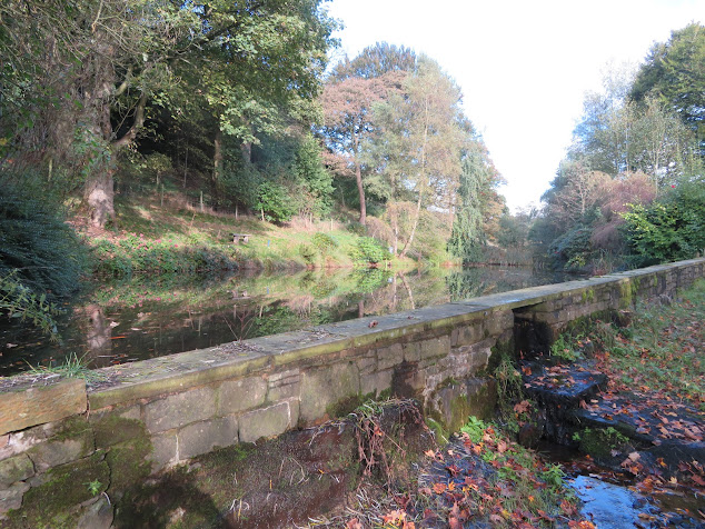
As we descended further from the moorlands we came across these ponds that are obviously used for fishing and they are overflowing the weir, onto the path between the two pools. They were obviously attached to the Birchencliff Farm.

Birchencliff Farm was built as a model farm in the early 1800's It had a three story farm house and two courtyards with farm buildings all around. It seems to have largely been converted into homes and I expect it is mainly older people there as it is very quiet, although not far from Macclesfield, Manchester airport etc.

As we followed the track down from the farm to the road we came across this building. At first I thought it was another 'tin tabernacle' chapel building, and we were surprised to see it was called the Coffee Tavern and was open, so it would have been a sin to not call in. It was a lovely place with the stove going and a highly polished floor, and several people all enjoying their food! It had been 1897 to celebrate Queen Victoria's Golden Jubilee and was used as a lending library. By the early 2000's it had become the Coffee Tavern. The food looked great and was not expensive. It is only about 20 mins from Bridge 18.

It has been a fantastic walk in the beautiful weather and a nice break from the gloomy weather.


Saturday, 16 October 2021

Macclesfield Miscellany.

 Unfortunately our time at Bugsworth is limited and we were off the next day. Luckily the weather was drier, if not sunnier!

There is a bit of colour in the trees now, but I have a feeling that as soon as there is any wind they will all be down.

Is this the 'Rodders' boat? Or another one? It was moored up on the Upper Peak Forest near Strines.

The house by Bridge 21 has a good view across the valley on a day like this. Not so much yesterday. The driver of the tanker parked up on the bridge apologised in advance just in case the weight of the truck collapsed the bridge!! he was obviously a little worried about it!

As we approached Marple Junction you pass Tramway Wharf which seems to be home to some old boats. Although it doesn't appear on the OS maps it was used as the transshipment point from Bugsworth Basin to the Lower Peak Forest Canal whilst the Marple Lock flight was being built. It took eight years to complete the locks so it would have been a very busy place indeed. It continued as a commercial wharf. It is hard to think that the Marple locks were abandoned in the 1960's and a lot of hard work and argument need to be undertaken to get them open so we can now cruise the Cheshire Ring.

The junction at Marple between the Peak Forest and the Macclesfield Canal didn't open until 1831. It was eerily quiet once again as we turned left onto the Macc and through the first of those lovely bridges.

This is a much better view of Goyt Mill as we approach from Marple.

Just another gratuitous shot of a bridge on the Macc. 

By Bridge 13 there is this nice man cave. It actually hides the original pill box that can just be glimpsed behind the greenhouse. This section of canal is a real drag as there are so many moored boats it takes for ever!

We were nearly at out destination, which was just as well as this boat was another that was going slowly. Luckily Helen had decided that she wanted to get her steps in so was walking the tow path and I was just keeping pace with her.

The bridges around High Poynton are not the classical shape as the area was a big coal mining area and the land consequently subsided over time. It was must quicker, and cheaper too, to build up the parapets and add on a girder bridge across the cut. So that is what they did.

Just before Lyme View Marina and by the Rams Clough Aqueduct C&RT have fortifying the sides of the canal with sand bags. This shows what a lovely job they do. The bags don't seem to be sewn closed but just folded under.

Foot long staples are then pushed in on the top layer to join each individual bag to the next and to the ones below. This picture is on the off side so it also looks like that every few layers of bags they staple them together too.

It was great to see this old lady still going strong. She was built in 1899 for Fellows, Morton and Clayton at their yard at Saltley. It was a composite iron horse drawn boat. It was fitted with a Bolinder engine in Yarwood's yard in Northwich in 1937. It was bought by the British Transport Commission in 1949 and passed to the British Waterways Board in 1963. After this it had the cabin extended. It was passed to C&RT in 2012 and is obviously still working and still looking in very good nick.

We moored up for the night just after Lyme View Marina and Bridge 18. The winding hole just by the bridge served a colliery on the tow path side. There was a plateway down to the canal but I'm not sure why the wharf was on the other side of the canal I'm not sure.
Bridge 18 is just off the map section at the bottom, as is the basin. The Miners Arms is still there and on Goggle Earth you can see the pit and plateway.


Friday, 15 October 2021

A bit about Bugsworth.

 We had a walk into Whaley Bridge, via Tesco's after we had moored up and had a cup of tea.

Just at the entrance to the basin is the wharf managers house and toll office. I was drawn to the line of windows, like a corridor on the east side. Some of them have bars on. I wondered if this was the toll office and where money changed hands so was kept secure

At the end of the canal at Whaley is the transshipment warehouse. You can see that there is a berth actually in the shed for loading undercover. The warehouse was built in 1801 and was originally three stories.

You can see at the other end that when the railway arrived at Whaley Bridge, from Cromford it was extended and the big doors on either side of the water allowed railway wagons in to transfer goods to/from the water in the dry too. The 3rd floor was removed in 1915 and trade died quickly when the tram way bringing limestone to Bugsworth etc. In the 1970/80's it was used as a hire base and as a boat fitters too. Various plans were made over the years that didn't come to anything but recently with grants from the local Council and C&RT have re-roofed the building and made it watertight and secure. It will now be used by a voluntary group called the High Peak Heritage Craft Centre and will be the site of courses in such as pottery weaving, silver-smithing etc etc.

Tod brook Reservoir had a lot of trouble the other year and there was a chance that it could have breached and flown down the valley. Fortunately that didn't happen, but it had to be drained and as it was one of the main providers of water for the Peak Forest Canal this causes problems with water levels. It seems that they are pumping water up from the River Goyt to keep the levels acceptable.

Currently the Upper Bssin  is closed and drained as they are repairing a wash wall. It was opened in 1796 so maybe is ready for a bit of TLC. It is supposed to reopen in December. On the right you can see the remains of a crane upright.

Looking through the bridge from the Middle Basin to the Lower Basin and with 'Holderness' moored up.

On the far side of the Middle Basin ar the Gnat Hole lime kilns. There were two lots of four here and one bank of four were destroyed when the bypass was built in the 1980's. It must have been an awful place to work with the smoke and smell and the dangers of the burned lime to the skin etc.

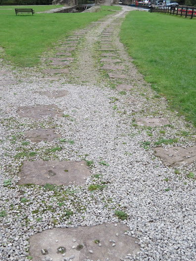
Bugsworth Basin was built at the end of a tramway from Dove Holes Quarries to export the limestone quarried there. It was a round 6 miles long and descended about 380 ft. It was a track of 4'2" gauge and had two inclined planes. It was a superb feat of engineering designed by Benjamin Outram and opened in 1796. Above you can see the sleeper blocks that the pedestals or saddles were bolted down to as the ran along the basin.

This is a replica of the wagons that were used. They carried a little over 2 tons and the gate on the front here was to allow them to be discharged using a tippler on a turntable.

'Holderness' not looking too bad from this distance, but doesn't warrant closer inspection. There is a constant procession of dog walkers in and around the basin so it it always seems busy. There is a cafe boat at the entrance that also houses the warden.

Here we are filling up with water and dumping the rubbish at the entrance.


Thursday, 14 October 2021

The weather may be dull, but not the canal.

 We left our mooring in very gloomy weather, but it was still and not raining.

As we cleared the town we were aware of a couple of these bulls that were indifferent to the weather. I don't think I would have got Helen through the field on a footpath though!

As we cleared Lyme View Marina there was a series of work boats serving the two blokes who were building walls of sand bags. As we passed the workers told me that they use two sorts of sand bags, below and above water. They are filled with some sort of concrete and the hessian bags are biodegradable leaving the concrete wall there.

We were soon in the kingdom of the shiny boat brigade as we passed Lord Vernon's Wharf and Braidbar boats. I was trying to work out how many a year they must make just from their production numbers and the year of their registry. I cam up with around twenty a year, but that sounds far too many.

This is the entrance to the High Lane Canal arm that is now the home of the North Cheshire Cruising Club and has been since WWII. It had originally being dug in 1830 and was a 'T' shape. One side of the head has been lost. It was for coal loading from the nearby pits but also as a transfer wharf from road to boat and vica versa. It was from here that Pickford's started out as canal carriers. The NCCC was formed in 1943 and are still there.

Goyt Mill was the last mill to built in the area and it was started in 1905. It was for spinning cotton. It lasted until 1960 and then, after a number of years was used for preforming plastic mouldings. It is now home to several businesses.

Although there are new houses on part of the old wharf at Marple, but the service wharf and the Stockton Canal Charity boat berth is still there, and nothing has happened at the warehouse has happened.

There was no moving boats as we approached the junction at Marple. We turned right up the Upper Peak Forest. The house opposite the junction was once part of James Jink's boat yard. Just up the Peak Forest was an arm that served the lime kilns of Samuel Oldknow who was a local business man. They are now moorings and the Ex. Servicemen's club.

The low cloud lifted for a while and it was good to see the hills.

There are no locks on the Upper Peak Forest but there are four bridges that need working. This is the first and it is a windlass operated on. Helen seems to be putting her back into it as I clicked the camera.

The next is another manual operated bridge, but  a swing bridge this time. The next one was an electric one and it was opened as we approached. There were two boats coming down and the second one was fellow blogger 'Cleddau'. Before I saw the name I was greeted with a 'I read your blog'. I was so shocked that somebody admits to reading it that I forgot to reciprocate, as I read theirs too!

As I came through the bridge I spied these hands. At a bit of a distance it looked like somebody had trained so trunks to look like hands, but as we got closer that they were plastic. Still, it looked quite striking.

As we approached Newtown the Swizzles-Matlow factory revealed its self with the sweet smell in the air. The factory relocated here in WWII, and has never left.

The Midland Railway built the Newtown rail viaduct for their line from London and Derby to Manchester in 1867, and reminds me of that one along the Llangollen Canal.

From Disley we got stuck behind a boat that required us to go no more than tickover the whole way from there. Luckily they went on to the basin at Whaley and we turned to port for a berth at Bugsworth Basin.

We went straight on and moored in the Lower Basin without winding, and then went to Tesco's near the junction, and then on into Whaley Bridge, but more of that later.